You are here: Home > Network List > TA - USArray Transportable Network (new EarthScope stations) Stations List
> Station E42A Champion, MI, USA > Earthquake Result Viewer
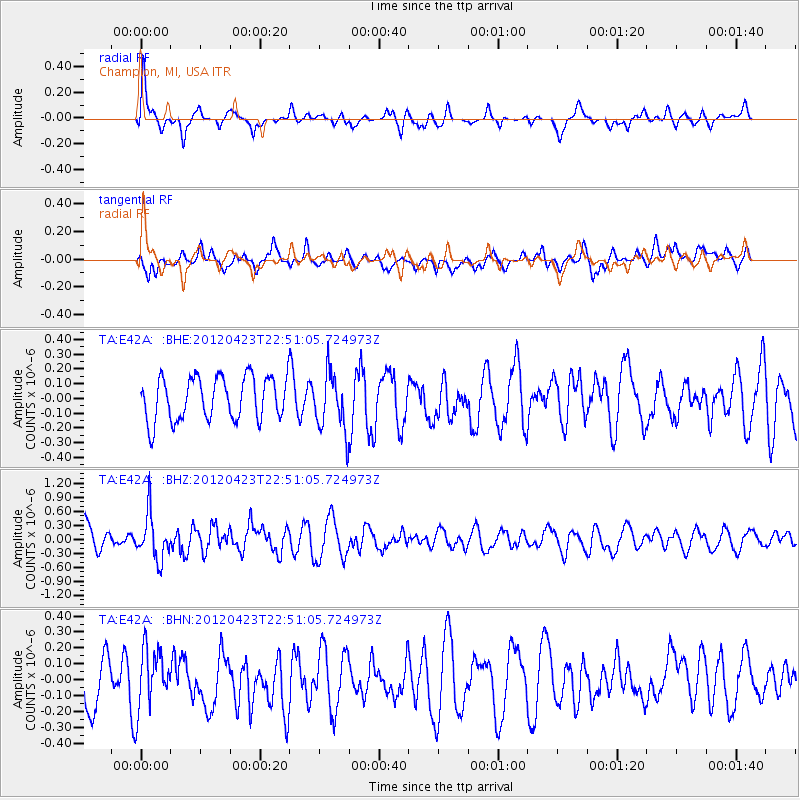
E42A Champion, MI, USA - Earthquake Result Viewer
*The percent match for this event was below the threshold and hence no stack was calculated.
| Earthquake location: |
Kuril Islands |
| Earthquake latitude/longitude: |
48.4/154.7 |
| Earthquake time(UTC): |
2012/04/23 (114) 22:40:22 GMT |
| Earthquake Depth: |
31 km |
| Earthquake Magnitude: |
5.6 MW, 5.2 MS, 5.4 MB, 5.7 MW |
| Earthquake Catalog/Contributor: |
WHDF/NEIC |
|
| Network: |
TA USArray Transportable Network (new EarthScope stations) |
| Station: |
E42A Champion, MI, USA |
| Lat/Lon: |
46.43 N/87.91 W |
| Elevation: |
475 m |
|
| Distance: |
70.9 deg |
| Az: |
40.544 deg |
| Baz: |
321.219 deg |
| Ray Param: |
$rayparam |
*The percent match for this event was below the threshold and hence was not used in the summary stack. |
|
| Radial Match: |
62.918507 % |
| Radial Bump: |
400 |
| Transverse Match: |
58.157955 % |
| Transverse Bump: |
400 |
| SOD ConfigId: |
446234 |
| Insert Time: |
2012-07-21 13:16:49.782 +0000 |
| GWidth: |
2.5 |
| Max Bumps: |
400 |
| Tol: |
0.001 |
|
Signal To Noise
| Channel | StoN | STA | LTA |
| TA:E42A: :BHZ:20120423T22:51:05.724973Z | 1.8786728 | 4.85765E-7 | 2.5856818E-7 |
| TA:E42A: :BHN:20120423T22:51:05.724973Z | 0.9762082 | 1.8924543E-7 | 1.9385764E-7 |
| TA:E42A: :BHE:20120423T22:51:05.724973Z | 1.3402071 | 1.9651442E-7 | 1.4662989E-7 |
| Arrivals |
| Ps | |
| PpPs | |
| PsPs/PpSs | |


