You are here: Home > Network List > NE - New England Seismic Network Stations List
> Station BCX Chestnut Hill, MA, USA > Earthquake Result Viewer
BCX Chestnut Hill, MA, USA - Earthquake Result Viewer
| Earthquake location: |
Guerrero, Mexico |
| Earthquake latitude/longitude: |
17.4/-100.7 |
| Earthquake time(UTC): |
2014/05/08 (128) 17:00:17 GMT |
| Earthquake Depth: |
24 km |
| Earthquake Magnitude: |
6.4 MWW, 6.8 MI |
| Earthquake Catalog/Contributor: |
NEIC PDE/NEIC COMCAT |
|
| Network: |
NE New England Seismic Network |
| Station: |
BCX Chestnut Hill, MA, USA |
| Lat/Lon: |
42.33 N/71.17 W |
| Elevation: |
60 m |
|
| Distance: |
35.4 deg |
| Az: |
39.102 deg |
| Baz: |
234.315 deg |
| Ray Param: |
0.077232055 |
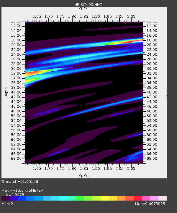
| Estimated Moho Depth: |
18.0 km |
| Estimated Crust Vp/Vs: |
2.10 |
| Assumed Crust Vp: |
6.419 km/s |
| Estimated Crust Vs: |
3.06 km/s |
| Estimated Crust Poisson's Ratio: |
0.35 |
|
| Radial Match: |
91.55106 % |
| Radial Bump: |
181 |
| Transverse Match: |
78.60235 % |
| Transverse Bump: |
400 |
| SOD ConfigId: |
3390531 |
| Insert Time: |
2019-04-11 18:48:33.868 +0000 |
| GWidth: |
2.5 |
| Max Bumps: |
400 |
| Tol: |
0.001 |
|

Signal To Noise
| Channel | StoN | STA | LTA |
| NE:BCX:00:HHZ:20140508T17:06:41.038015Z | 31.552057 | 7.0042584E-6 | 2.2199055E-7 |
| NE:BCX:00:HH1:20140508T17:06:41.038015Z | 18.699839 | 3.047744E-6 | 1.6298236E-7 |
| NE:BCX:00:HH2:20140508T17:06:41.038015Z | 30.506956 | 3.9809524E-6 | 1.3049326E-7 |
| Arrivals |
| Ps | 3.3 SECOND |
| PpPs | 8.2 SECOND |
| PsPs/PpSs | 11 SECOND |


