You are here: Home > Network List > TA - USArray Transportable Network (new EarthScope stations) Stations List
> Station P58A Pank, Wackersville, MD, USA > Earthquake Result Viewer
P58A Pank, Wackersville, MD, USA - Earthquake Result Viewer
| Earthquake location: |
Guerrero, Mexico |
| Earthquake latitude/longitude: |
17.4/-100.7 |
| Earthquake time(UTC): |
2014/05/08 (128) 17:00:17 GMT |
| Earthquake Depth: |
24 km |
| Earthquake Magnitude: |
6.4 MWW, 6.8 MI |
| Earthquake Catalog/Contributor: |
NEIC PDE/NEIC COMCAT |
|
| Network: |
TA USArray Transportable Network (new EarthScope stations) |
| Station: |
P58A Pank, Wackersville, MD, USA |
| Lat/Lon: |
39.49 N/77.30 W |
| Elevation: |
139 m |
|
| Distance: |
29.9 deg |
| Az: |
37.916 deg |
| Baz: |
229.313 deg |
| Ray Param: |
0.07944253 |
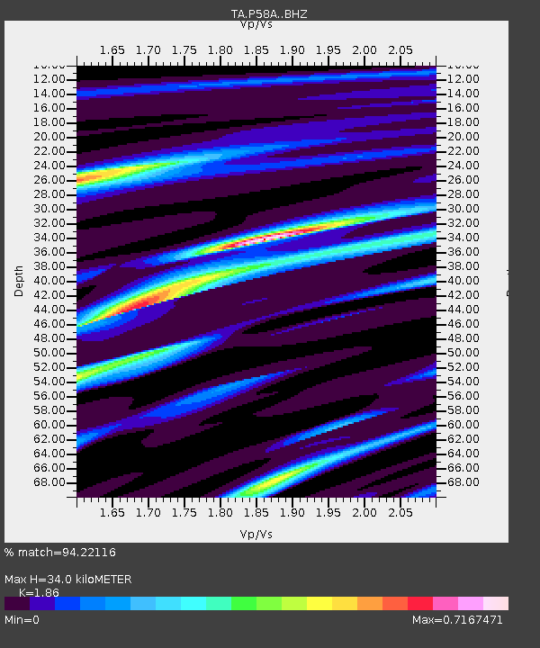
| Estimated Moho Depth: |
34.0 km |
| Estimated Crust Vp/Vs: |
1.86 |
| Assumed Crust Vp: |
6.419 km/s |
| Estimated Crust Vs: |
3.451 km/s |
| Estimated Crust Poisson's Ratio: |
0.30 |
|
| Radial Match: |
94.22116 % |
| Radial Bump: |
259 |
| Transverse Match: |
73.07705 % |
| Transverse Bump: |
400 |
| SOD ConfigId: |
3390531 |
| Insert Time: |
2019-04-11 18:49:29.763 +0000 |
| GWidth: |
2.5 |
| Max Bumps: |
400 |
| Tol: |
0.001 |
|

Signal To Noise
| Channel | StoN | STA | LTA |
| TA:P58A: :BHZ:20140508T17:05:53.999014Z | 77.23483 | 7.398438E-6 | 9.5791464E-8 |
| TA:P58A: :BHN:20140508T17:05:53.999014Z | 47.764412 | 3.4270727E-6 | 7.1749504E-8 |
| TA:P58A: :BHE:20140508T17:05:53.999014Z | 59.838264 | 3.525259E-6 | 5.8913127E-8 |
| Arrivals |
| Ps | 4.9 SECOND |
| PpPs | 14 SECOND |
| PsPs/PpSs | 19 SECOND |


