You are here: Home > Network List > X812 - Deep Structure of Three Continental Sutures in Eastern North America Stations List
> Station QM20 Hay Lake, Maine, USA > Earthquake Result Viewer
QM20 Hay Lake, Maine, USA - Earthquake Result Viewer
| Earthquake location: |
Guerrero, Mexico |
| Earthquake latitude/longitude: |
17.4/-100.7 |
| Earthquake time(UTC): |
2014/05/08 (128) 17:00:17 GMT |
| Earthquake Depth: |
24 km |
| Earthquake Magnitude: |
6.4 MWW, 6.8 MI |
| Earthquake Catalog/Contributor: |
NEIC PDE/NEIC COMCAT |
|
| Network: |
X8 Deep Structure of Three Continental Sutures in Eastern North America |
| Station: |
QM20 Hay Lake, Maine, USA |
| Lat/Lon: |
46.13 N/68.72 W |
| Elevation: |
207 m |
|
| Distance: |
39.0 deg |
| Az: |
35.758 deg |
| Baz: |
233.354 deg |
| Ray Param: |
0.07519035 |
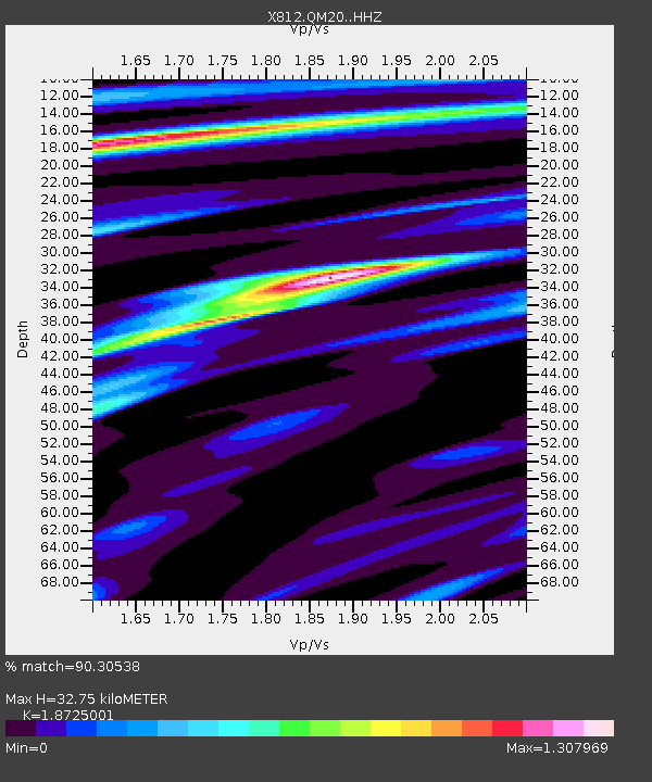
| Estimated Moho Depth: |
32.75 km |
| Estimated Crust Vp/Vs: |
1.87 |
| Assumed Crust Vp: |
6.419 km/s |
| Estimated Crust Vs: |
3.428 km/s |
| Estimated Crust Poisson's Ratio: |
0.30 |
|
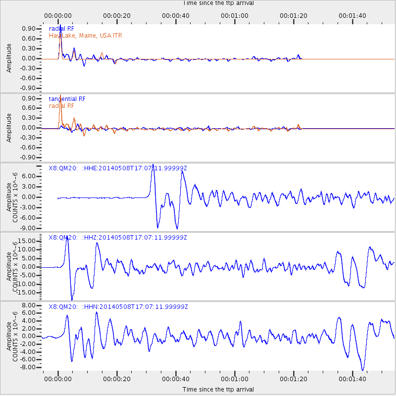
| Radial Match: |
90.30538 % |
| Radial Bump: |
272 |
| Transverse Match: |
80.08231 % |
| Transverse Bump: |
369 |
| SOD ConfigId: |
3390531 |
| Insert Time: |
2019-04-11 18:49:47.361 +0000 |
| GWidth: |
2.5 |
| Max Bumps: |
400 |
| Tol: |
0.001 |
|
Signal To Noise
| Channel | StoN | STA | LTA |
| X8:QM20: :HHZ:20140508T17:07:11.99999Z | 86.8807 | 9.007947E-6 | 1.0368179E-7 |
| X8:QM20: :HHN:20140508T17:07:11.99999Z | 17.362007 | 2.935533E-6 | 1.6907798E-7 |
| X8:QM20: :HHE:20140508T17:07:11.99999Z | 61.29568 | 4.559029E-6 | 7.437766E-8 |
| Arrivals |
| Ps | 4.8 SECOND |
| PpPs | 14 SECOND |
| PsPs/PpSs | 18 SECOND |


