You are here: Home > Network List > X812 - Deep Structure of Three Continental Sutures in Eastern North America Stations List
> Station QM15 Land Trust South, Maine, USA > Earthquake Result Viewer
QM15 Land Trust South, Maine, USA - Earthquake Result Viewer
| Earthquake location: |
Guerrero, Mexico |
| Earthquake latitude/longitude: |
17.4/-100.7 |
| Earthquake time(UTC): |
2014/05/08 (128) 17:00:17 GMT |
| Earthquake Depth: |
24 km |
| Earthquake Magnitude: |
6.4 MWW, 6.8 MI |
| Earthquake Catalog/Contributor: |
NEIC PDE/NEIC COMCAT |
|
| Network: |
X8 Deep Structure of Three Continental Sutures in Eastern North America |
| Station: |
QM15 Land Trust South, Maine, USA |
| Lat/Lon: |
45.09 N/67.84 W |
| Elevation: |
151 m |
|
| Distance: |
38.9 deg |
| Az: |
37.667 deg |
| Baz: |
235.465 deg |
| Ray Param: |
0.075248 |
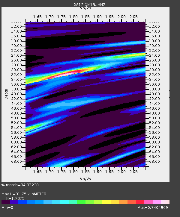
| Estimated Moho Depth: |
31.75 km |
| Estimated Crust Vp/Vs: |
1.77 |
| Assumed Crust Vp: |
6.419 km/s |
| Estimated Crust Vs: |
3.632 km/s |
| Estimated Crust Poisson's Ratio: |
0.26 |
|
| Radial Match: |
94.37228 % |
| Radial Bump: |
218 |
| Transverse Match: |
75.42906 % |
| Transverse Bump: |
400 |
| SOD ConfigId: |
3390531 |
| Insert Time: |
2019-04-11 18:49:49.974 +0000 |
| GWidth: |
2.5 |
| Max Bumps: |
400 |
| Tol: |
0.001 |
|

Signal To Noise
| Channel | StoN | STA | LTA |
| X8:QM15: :HHZ:20140508T17:07:11.159994Z | 64.75835 | 7.4400677E-6 | 1.1488971E-7 |
| X8:QM15: :HHN:20140508T17:07:11.159994Z | 12.034349 | 2.129135E-6 | 1.7692149E-7 |
| X8:QM15: :HHE:20140508T17:07:11.159994Z | 57.609993 | 4.6795026E-6 | 8.122727E-8 |
| Arrivals |
| Ps | 4.1 SECOND |
| PpPs | 13 SECOND |
| PsPs/PpSs | 17 SECOND |


