You are here: Home > Network List > X812 - Deep Structure of Three Continental Sutures in Eastern North America Stations List
> Station QM80 Route du Nord, Quebec, Canada > Earthquake Result Viewer
QM80 Route du Nord, Quebec, Canada - Earthquake Result Viewer
| Earthquake location: |
Guerrero, Mexico |
| Earthquake latitude/longitude: |
17.4/-100.7 |
| Earthquake time(UTC): |
2014/05/08 (128) 17:00:17 GMT |
| Earthquake Depth: |
24 km |
| Earthquake Magnitude: |
6.4 MWW, 6.8 MI |
| Earthquake Catalog/Contributor: |
NEIC PDE/NEIC COMCAT |
|
| Network: |
X8 Deep Structure of Three Continental Sutures in Eastern North America |
| Station: |
QM80 Route du Nord, Quebec, Canada |
| Lat/Lon: |
50.96 N/75.23 W |
| Elevation: |
371 m |
|
| Distance: |
39.2 deg |
| Az: |
25.467 deg |
| Baz: |
220.489 deg |
| Ray Param: |
0.07510693 |
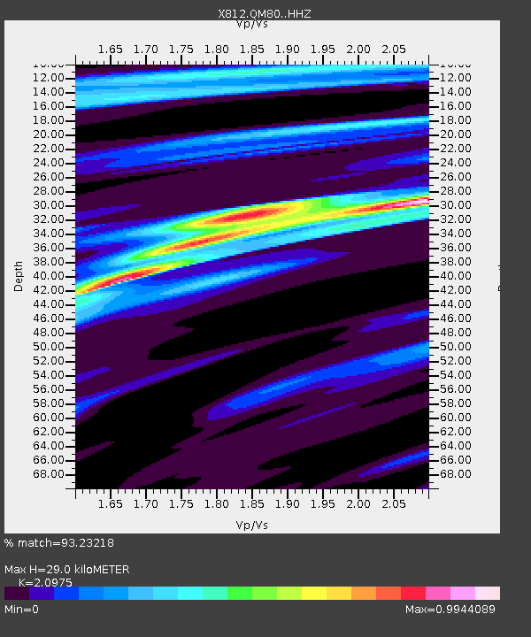
| Estimated Moho Depth: |
29.0 km |
| Estimated Crust Vp/Vs: |
2.10 |
| Assumed Crust Vp: |
6.61 km/s |
| Estimated Crust Vs: |
3.151 km/s |
| Estimated Crust Poisson's Ratio: |
0.35 |
|
| Radial Match: |
93.23218 % |
| Radial Bump: |
171 |
| Transverse Match: |
79.26008 % |
| Transverse Bump: |
400 |
| SOD ConfigId: |
3390531 |
| Insert Time: |
2019-04-11 18:49:59.968 +0000 |
| GWidth: |
2.5 |
| Max Bumps: |
400 |
| Tol: |
0.001 |
|

Signal To Noise
| Channel | StoN | STA | LTA |
| X8:QM80: :HHZ:20140508T17:07:13.189993Z | 78.45475 | 7.0207743E-6 | 8.9488196E-8 |
| X8:QM80: :HHN:20140508T17:07:13.189993Z | 28.492266 | 3.4863883E-6 | 1.2236262E-7 |
| X8:QM80: :HHE:20140508T17:07:13.189993Z | 26.898016 | 2.2141587E-6 | 8.231681E-8 |
| Arrivals |
| Ps | 5.1 SECOND |
| PpPs | 13 SECOND |
| PsPs/PpSs | 18 SECOND |


