You are here: Home > Network List > TA - USArray Transportable Network (new EarthScope stations) Stations List
> Station G35A Watkins, MN, USA > Earthquake Result Viewer
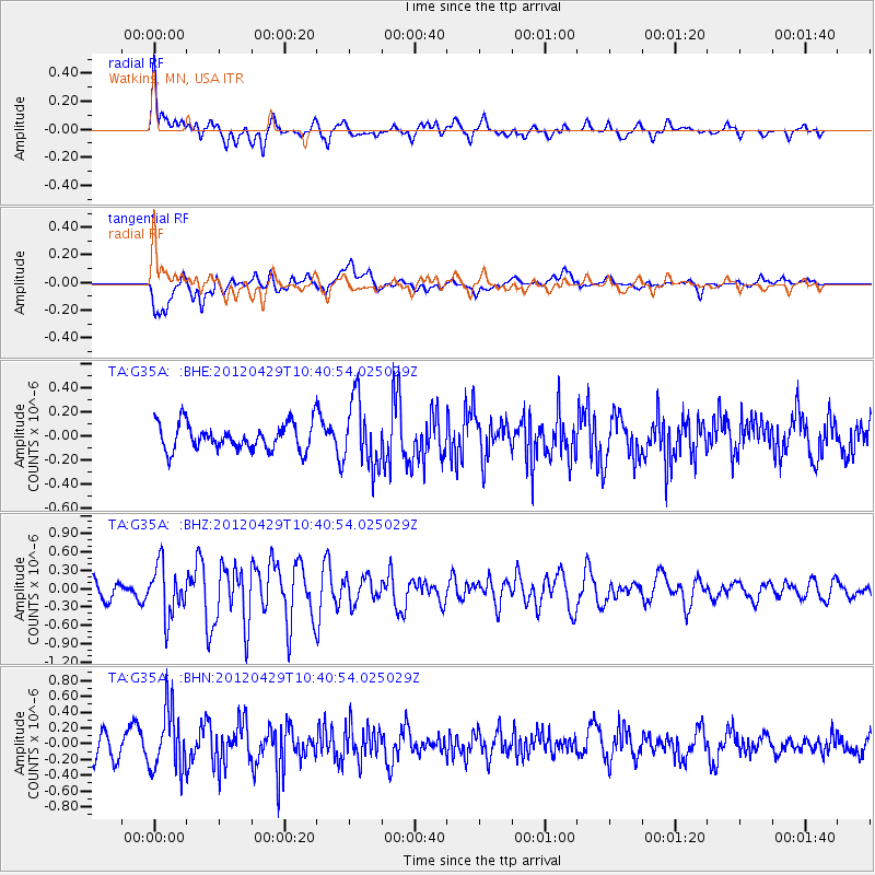
G35A Watkins, MN, USA - Earthquake Result Viewer
*The percent match for this event was below the threshold and hence no stack was calculated.
| Earthquake location: |
Near East Coast Of Honshu, Japan |
| Earthquake latitude/longitude: |
35.6/140.3 |
| Earthquake time(UTC): |
2012/04/29 (120) 10:28:51 GMT |
| Earthquake Depth: |
44 km |
| Earthquake Magnitude: |
5.6 MB, 5.2 MS, 5.8 MW, 5.8 MW |
| Earthquake Catalog/Contributor: |
WHDF/NEIC |
|
| Network: |
TA USArray Transportable Network (new EarthScope stations) |
| Station: |
G35A Watkins, MN, USA |
| Lat/Lon: |
45.22 N/94.49 W |
| Elevation: |
361 m |
|
| Distance: |
85.5 deg |
| Az: |
35.419 deg |
| Baz: |
318.065 deg |
| Ray Param: |
$rayparam |
*The percent match for this event was below the threshold and hence was not used in the summary stack. |
|
| Radial Match: |
64.488106 % |
| Radial Bump: |
400 |
| Transverse Match: |
52.951626 % |
| Transverse Bump: |
400 |
| SOD ConfigId: |
446234 |
| Insert Time: |
2012-07-28 06:36:32.399 +0000 |
| GWidth: |
2.5 |
| Max Bumps: |
400 |
| Tol: |
0.001 |
|
Signal To Noise
| Channel | StoN | STA | LTA |
| TA:G35A: :BHZ:20120429T10:40:54.025029Z | 3.7058113 | 4.150508E-7 | 1.1199999E-7 |
| TA:G35A: :BHN:20120429T10:40:54.025029Z | 2.4400966 | 3.8703047E-7 | 1.5861278E-7 |
| TA:G35A: :BHE:20120429T10:40:54.025029Z | 2.5050297 | 2.7457983E-7 | 1.09611406E-7 |
| Arrivals |
| Ps | |
| PpPs | |
| PsPs/PpSs | |


