You are here: Home > Network List > G - GEOSCOPE Stations List
> Station KOG Kourou, French Guyana > Earthquake Result Viewer
KOG Kourou, French Guyana - Earthquake Result Viewer
| Earthquake location: |
South Sandwich Islands Region |
| Earthquake latitude/longitude: |
-55.8/-28.6 |
| Earthquake time(UTC): |
1995/08/18 (230) 02:20:35 GMT |
| Earthquake Depth: |
33 km |
| Earthquake Magnitude: |
5.5 MB |
| Earthquake Catalog/Contributor: |
WHDF/NEIC |
|
| Network: |
G GEOSCOPE |
| Station: |
KOG Kourou, French Guyana |
| Lat/Lon: |
5.21 N/52.73 W |
| Elevation: |
10 m |
|
| Distance: |
64.0 deg |
| Az: |
333.102 deg |
| Baz: |
165.139 deg |
| Ray Param: |
0.05917751 |
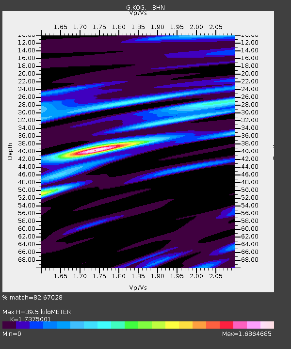
| Estimated Moho Depth: |
39.5 km |
| Estimated Crust Vp/Vs: |
1.74 |
| Assumed Crust Vp: |
6.472 km/s |
| Estimated Crust Vs: |
3.725 km/s |
| Estimated Crust Poisson's Ratio: |
0.25 |
|
| Radial Match: |
82.67028 % |
| Radial Bump: |
400 |
| Transverse Match: |
67.62654 % |
| Transverse Bump: |
400 |
| SOD ConfigId: |
4480 |
| Insert Time: |
2010-02-26 23:31:04.899 +0000 |
| GWidth: |
2.5 |
| Max Bumps: |
400 |
| Tol: |
0.001 |
|
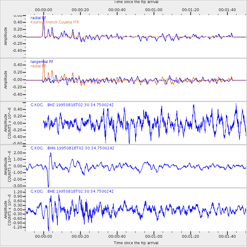
Signal To Noise
| Channel | StoN | STA | LTA |
| G:KOG: :BHN:19950818T02:30:34.750024Z | 4.215499 | 1.2345758E-6 | 2.928659E-7 |
| G:KOG: :BHE:19950818T02:30:34.750024Z | 3.419384 | 5.693946E-7 | 1.6651965E-7 |
| G:KOG: :BHZ:19950818T02:30:34.750024Z | 1.8721883 | 2.0569577E-7 | 1.0986916E-7 |
| Arrivals |
| Ps | 4.7 SECOND |
| PpPs | 16 SECOND |
| PsPs/PpSs | 21 SECOND |


