You are here: Home > Network List > TA - USArray Transportable Network (new EarthScope stations) Stations List
> Station M36A Felix, Anita, IA, USA > Earthquake Result Viewer
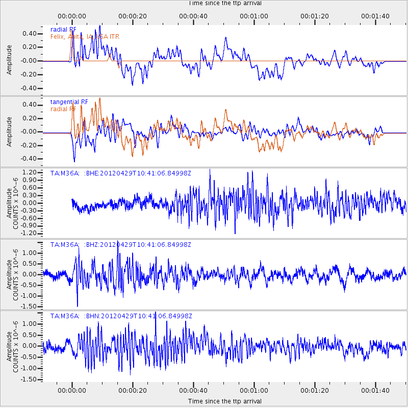
M36A Felix, Anita, IA, USA - Earthquake Result Viewer
*The percent match for this event was below the threshold and hence no stack was calculated.
| Earthquake location: |
Near East Coast Of Honshu, Japan |
| Earthquake latitude/longitude: |
35.6/140.3 |
| Earthquake time(UTC): |
2012/04/29 (120) 10:28:51 GMT |
| Earthquake Depth: |
44 km |
| Earthquake Magnitude: |
5.6 MB, 5.2 MS, 5.8 MW, 5.8 MW |
| Earthquake Catalog/Contributor: |
WHDF/NEIC |
|
| Network: |
TA USArray Transportable Network (new EarthScope stations) |
| Station: |
M36A Felix, Anita, IA, USA |
| Lat/Lon: |
41.45 N/94.80 W |
| Elevation: |
430 m |
|
| Distance: |
88.2 deg |
| Az: |
38.112 deg |
| Baz: |
317.997 deg |
| Ray Param: |
$rayparam |
*The percent match for this event was below the threshold and hence was not used in the summary stack. |
|
| Radial Match: |
54.06595 % |
| Radial Bump: |
400 |
| Transverse Match: |
62.44218 % |
| Transverse Bump: |
400 |
| SOD ConfigId: |
446234 |
| Insert Time: |
2012-07-28 06:38:06.160 +0000 |
| GWidth: |
2.5 |
| Max Bumps: |
400 |
| Tol: |
0.001 |
|
Signal To Noise
| Channel | StoN | STA | LTA |
| TA:M36A: :BHZ:20120429T10:41:06.84998Z | 4.9066377 | 5.192942E-7 | 1.05835035E-7 |
| TA:M36A: :BHN:20120429T10:41:06.84998Z | 2.2390301 | 3.7120816E-7 | 1.6578971E-7 |
| TA:M36A: :BHE:20120429T10:41:06.84998Z | 1.5814693 | 2.3995977E-7 | 1.5173217E-7 |
| Arrivals |
| Ps | |
| PpPs | |
| PsPs/PpSs | |


