You are here: Home > Network List > TA - USArray Transportable Network (new EarthScope stations) Stations List
> Station K42A Prairie Point, Evansville, WI, USA > Earthquake Result Viewer
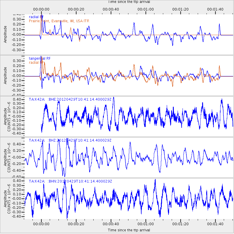
K42A Prairie Point, Evansville, WI, USA - Earthquake Result Viewer
*The percent match for this event was below the threshold and hence no stack was calculated.
| Earthquake location: |
Near East Coast Of Honshu, Japan |
| Earthquake latitude/longitude: |
35.6/140.3 |
| Earthquake time(UTC): |
2012/04/29 (120) 10:28:51 GMT |
| Earthquake Depth: |
44 km |
| Earthquake Magnitude: |
5.6 MB, 5.2 MS, 5.8 MW, 5.8 MW |
| Earthquake Catalog/Contributor: |
WHDF/NEIC |
|
| Network: |
TA USArray Transportable Network (new EarthScope stations) |
| Station: |
K42A Prairie Point, Evansville, WI, USA |
| Lat/Lon: |
42.78 N/89.35 W |
| Elevation: |
302 m |
|
| Distance: |
89.8 deg |
| Az: |
34.158 deg |
| Baz: |
321.573 deg |
| Ray Param: |
$rayparam |
*The percent match for this event was below the threshold and hence was not used in the summary stack. |
|
| Radial Match: |
54.113953 % |
| Radial Bump: |
400 |
| Transverse Match: |
57.93797 % |
| Transverse Bump: |
400 |
| SOD ConfigId: |
446234 |
| Insert Time: |
2012-07-28 06:42:59.560 +0000 |
| GWidth: |
2.5 |
| Max Bumps: |
400 |
| Tol: |
0.001 |
|
Signal To Noise
| Channel | StoN | STA | LTA |
| TA:K42A: :BHZ:20120429T10:41:14.400029Z | 3.0243967 | 3.0646174E-7 | 1.0132988E-7 |
| TA:K42A: :BHN:20120429T10:41:14.400029Z | 1.3608718 | 1.2884847E-7 | 9.468083E-8 |
| TA:K42A: :BHE:20120429T10:41:14.400029Z | 0.9753801 | 1.486551E-7 | 1.5240735E-7 |
| Arrivals |
| Ps | |
| PpPs | |
| PsPs/PpSs | |


