You are here: Home > Network List > TA - USArray Transportable Network (new EarthScope stations) Stations List
> Station T47A Sharon Grove, KY, USA > Earthquake Result Viewer
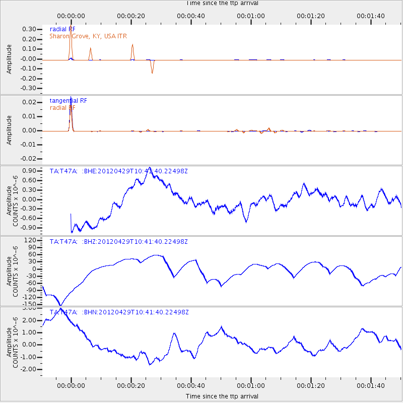
T47A Sharon Grove, KY, USA - Earthquake Result Viewer
*The percent match for this event was below the threshold and hence no stack was calculated.
| Earthquake location: |
Near East Coast Of Honshu, Japan |
| Earthquake latitude/longitude: |
35.6/140.3 |
| Earthquake time(UTC): |
2012/04/29 (120) 10:28:51 GMT |
| Earthquake Depth: |
44 km |
| Earthquake Magnitude: |
5.6 MB, 5.2 MS, 5.8 MW, 5.8 MW |
| Earthquake Catalog/Contributor: |
WHDF/NEIC |
|
| Network: |
TA USArray Transportable Network (new EarthScope stations) |
| Station: |
T47A Sharon Grove, KY, USA |
| Lat/Lon: |
36.99 N/87.11 W |
| Elevation: |
217 m |
|
| Distance: |
95.4 deg |
| Az: |
36.337 deg |
| Baz: |
322.907 deg |
| Ray Param: |
$rayparam |
*The percent match for this event was below the threshold and hence was not used in the summary stack. |
|
| Radial Match: |
98.47971 % |
| Radial Bump: |
157 |
| Transverse Match: |
99.36544 % |
| Transverse Bump: |
53 |
| SOD ConfigId: |
446234 |
| Insert Time: |
2012-07-28 06:43:37.101 +0000 |
| GWidth: |
2.5 |
| Max Bumps: |
400 |
| Tol: |
0.001 |
|
Signal To Noise
| Channel | StoN | STA | LTA |
| TA:T47A: :BHZ:20120429T10:41:40.22498Z | 1.3594221 | 1.235186E-4 | 9.086111E-5 |
| TA:T47A: :BHN:20120429T10:41:40.22498Z | 1.357233 | 2.5912777E-6 | 1.9092356E-6 |
| TA:T47A: :BHE:20120429T10:41:40.22498Z | 1.3963627 | 7.784433E-7 | 5.5747927E-7 |
| Arrivals |
| Ps | |
| PpPs | |
| PsPs/PpSs | |


