You are here: Home > Network List > CI - Caltech Regional Seismic Network Stations List
> Station MPP McPhearson Peak > Earthquake Result Viewer
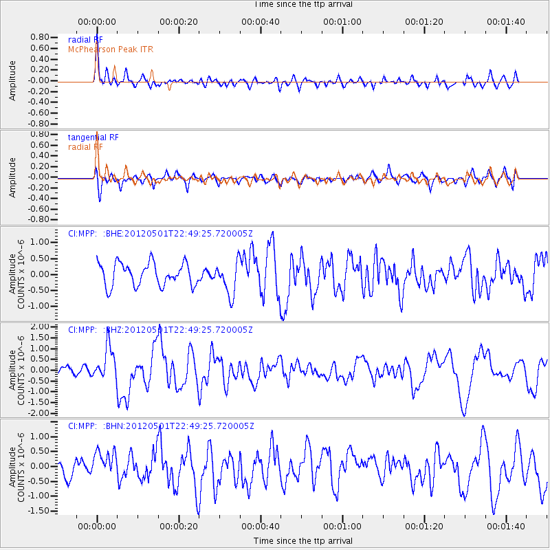
MPP McPhearson Peak - Earthquake Result Viewer
*The percent match for this event was below the threshold and hence no stack was calculated.
| Earthquake location: |
Near Coast Of Chiapas, Mexico |
| Earthquake latitude/longitude: |
14.4/-92.9 |
| Earthquake time(UTC): |
2012/05/01 (122) 22:43:33 GMT |
| Earthquake Depth: |
14 km |
| Earthquake Magnitude: |
5.6 MB, 5.8 MS, 6.0 MW, 5.9 MW |
| Earthquake Catalog/Contributor: |
WHDF/NEIC |
|
| Network: |
CI Caltech Regional Seismic Network |
| Station: |
MPP McPhearson Peak |
| Lat/Lon: |
34.89 N/119.81 W |
| Elevation: |
1739 m |
|
| Distance: |
31.7 deg |
| Az: |
314.908 deg |
| Baz: |
123.393 deg |
| Ray Param: |
$rayparam |
*The percent match for this event was below the threshold and hence was not used in the summary stack. |
|
| Radial Match: |
75.915016 % |
| Radial Bump: |
400 |
| Transverse Match: |
55.113823 % |
| Transverse Bump: |
400 |
| SOD ConfigId: |
446234 |
| Insert Time: |
2012-07-28 07:09:25.162 +0000 |
| GWidth: |
2.5 |
| Max Bumps: |
400 |
| Tol: |
0.001 |
|
Signal To Noise
| Channel | StoN | STA | LTA |
| CI:MPP: :BHZ:20120501T22:49:25.720005Z | 3.6250057 | 7.974412E-7 | 2.1998343E-7 |
| CI:MPP: :BHN:20120501T22:49:25.720005Z | 0.98651975 | 4.2928673E-7 | 4.3515269E-7 |
| CI:MPP: :BHE:20120501T22:49:25.720005Z | 1.5276809 | 5.38591E-7 | 3.5255462E-7 |
| Arrivals |
| Ps | |
| PpPs | |
| PsPs/PpSs | |


