You are here: Home > Network List > TA - USArray Transportable Network (new EarthScope stations) Stations List
> Station D32A Dogwood Acres, Gardner, ND, USA > Earthquake Result Viewer
D32A Dogwood Acres, Gardner, ND, USA - Earthquake Result Viewer
| Earthquake location: |
Near Coast Of Chiapas, Mexico |
| Earthquake latitude/longitude: |
14.4/-92.9 |
| Earthquake time(UTC): |
2012/05/01 (122) 22:43:33 GMT |
| Earthquake Depth: |
14 km |
| Earthquake Magnitude: |
5.6 MB, 5.8 MS, 6.0 MW, 5.9 MW |
| Earthquake Catalog/Contributor: |
WHDF/NEIC |
|
| Network: |
TA USArray Transportable Network (new EarthScope stations) |
| Station: |
D32A Dogwood Acres, Gardner, ND, USA |
| Lat/Lon: |
47.14 N/97.02 W |
| Elevation: |
280 m |
|
| Distance: |
32.8 deg |
| Az: |
354.811 deg |
| Baz: |
172.625 deg |
| Ray Param: |
0.0784726 |
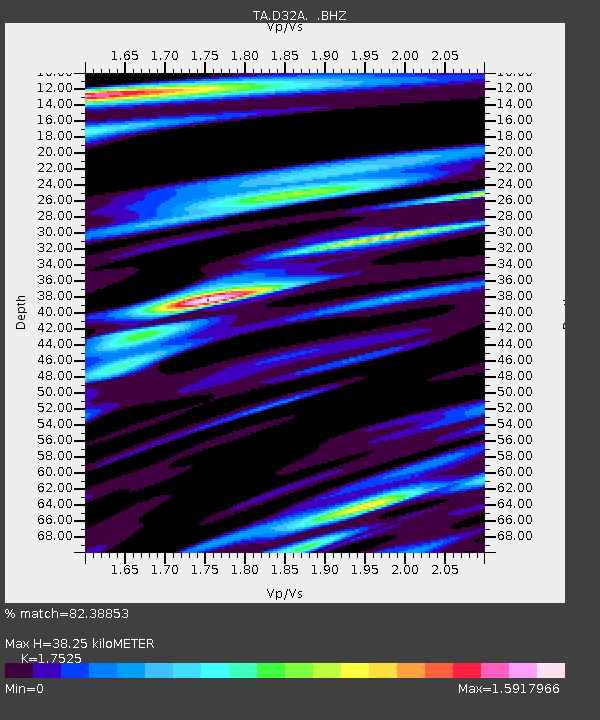
| Estimated Moho Depth: |
38.25 km |
| Estimated Crust Vp/Vs: |
1.75 |
| Assumed Crust Vp: |
6.498 km/s |
| Estimated Crust Vs: |
3.708 km/s |
| Estimated Crust Poisson's Ratio: |
0.26 |
|
| Radial Match: |
82.38853 % |
| Radial Bump: |
400 |
| Transverse Match: |
41.510815 % |
| Transverse Bump: |
400 |
| SOD ConfigId: |
446234 |
| Insert Time: |
2012-07-28 07:18:15.268 +0000 |
| GWidth: |
2.5 |
| Max Bumps: |
400 |
| Tol: |
0.001 |
|
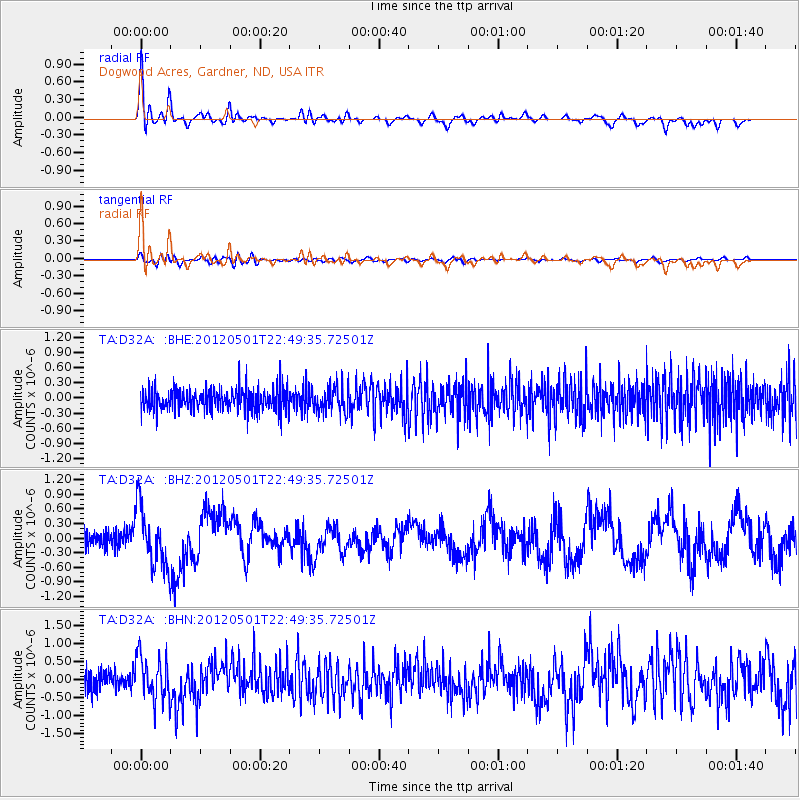
Signal To Noise
| Channel | StoN | STA | LTA |
| TA:D32A: :BHZ:20120501T22:49:35.72501Z | 2.9632106 | 6.1374976E-7 | 2.0712325E-7 |
| TA:D32A: :BHN:20120501T22:49:35.72501Z | 2.5355194 | 6.137813E-7 | 2.4207318E-7 |
| TA:D32A: :BHE:20120501T22:49:35.72501Z | 1.1854389 | 2.6399456E-7 | 2.2269774E-7 |
| Arrivals |
| Ps | 4.8 SECOND |
| PpPs | 15 SECOND |
| PsPs/PpSs | 20 SECOND |


