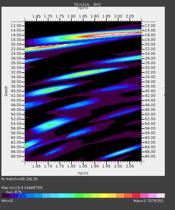
H31A Wolsey, SD, USA - Earthquake Result Viewer
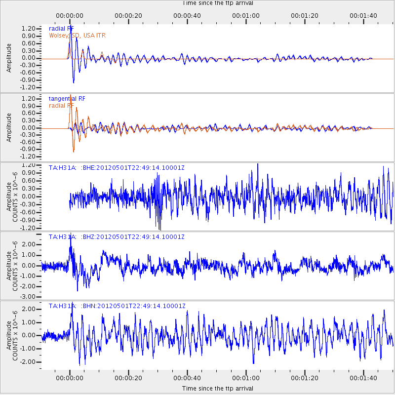
Earthquake location: Near Coast Of Chiapas, Mexico
Earthquake latitude/longitude: 14.4/-92.9
Earthquake time(UTC): 2012/05/01 (122) 22:43:33 GMT
Earthquake Depth: 14 km
Earthquake Magnitude: 5.6 MB, 5.8 MS, 6.0 MW, 5.9 MW
Earthquake Catalog/Contributor: WHDF/NEIC
Network: TA USArray Transportable Network (new EarthScope stations)
Station: H31A Wolsey, SD, USA
Lat/Lon: 44.48 N/98.48 W
Elevation: 415 m
Distance: 30.4 deg
Az: 352.088 deg
Baz: 169.261 deg
Ray Param: 0.07934292
Estimated Moho Depth: 15.5 km
Estimated Crust Vp/Vs: 1.98
Assumed Crust Vp: 6.53 km/s
Estimated Crust Vs: 3.307 km/s
Estimated Crust Poisson's Ratio: 0.33
Radial Match: 89.26128 %
Radial Bump: 400
Transverse Match: 64.76525 %
Transverse Bump: 400
SOD ConfigId: 446234
Insert Time: 2012-07-28 07:18:43.119 +0000
GWidth: 2.5
Max Bumps: 400
Tol: 0.001

Signal To Noise

ChannelStoNSTALTA
TA:H31A: :BHZ:20120501T22:49:14.10001Z4.2832041.0581647E-62.470498E-7
TA:H31A: :BHN:20120501T22:49:14.10001Z4.7912779.9956E-72.086208E-7
TA:H31A: :BHE:20120501T22:49:14.10001Z2.59887935.097273E-71.961335E-7
Arrivals
Ps2.5 SECOND
PpPs6.6 SECOND
PsPs/PpSs9.0 SECOND