You are here: Home > Network List > G - GEOSCOPE Stations List
> Station KOG Kourou, French Guyana > Earthquake Result Viewer
KOG Kourou, French Guyana - Earthquake Result Viewer
| Earthquake location: |
Near Coast Of Peru |
| Earthquake latitude/longitude: |
-14.5/-76.3 |
| Earthquake time(UTC): |
1997/02/09 (040) 12:32:36 GMT |
| Earthquake Depth: |
33 km |
| Earthquake Magnitude: |
5.7 MB, 5.8 MS, 6.1 UNKNOWN, 6.1 MW |
| Earthquake Catalog/Contributor: |
WHDF/NEIC |
|
| Network: |
G GEOSCOPE |
| Station: |
KOG Kourou, French Guyana |
| Lat/Lon: |
5.21 N/52.73 W |
| Elevation: |
10 m |
|
| Distance: |
30.5 deg |
| Az: |
51.692 deg |
| Baz: |
229.744 deg |
| Ray Param: |
0.07929448 |
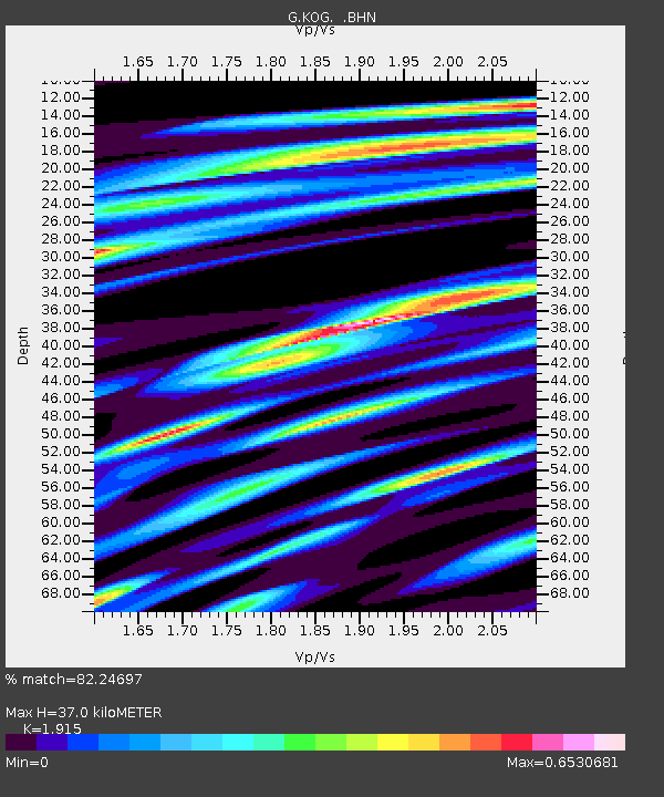
| Estimated Moho Depth: |
37.0 km |
| Estimated Crust Vp/Vs: |
1.91 |
| Assumed Crust Vp: |
6.472 km/s |
| Estimated Crust Vs: |
3.38 km/s |
| Estimated Crust Poisson's Ratio: |
0.31 |
|
| Radial Match: |
82.24697 % |
| Radial Bump: |
269 |
| Transverse Match: |
52.062927 % |
| Transverse Bump: |
400 |
| SOD ConfigId: |
6273 |
| Insert Time: |
2010-02-26 23:31:50.518 +0000 |
| GWidth: |
2.5 |
| Max Bumps: |
400 |
| Tol: |
0.001 |
|

Signal To Noise
| Channel | StoN | STA | LTA |
| G:KOG: :BHN:19970209T12:38:15.598987Z | 1.3168771 | 4.972173E-7 | 3.7757303E-7 |
| G:KOG: :BHE:19970209T12:38:15.598987Z | 1.8298547 | 4.829944E-7 | 2.639523E-7 |
| G:KOG: :BHZ:19970209T12:38:15.598987Z | 2.9929683 | 1.5297754E-6 | 5.111232E-7 |
| Arrivals |
| Ps | 5.6 SECOND |
| PpPs | 15 SECOND |
| PsPs/PpSs | 21 SECOND |


