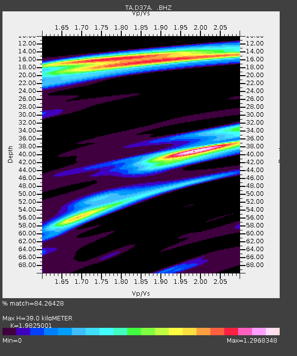
D37A Cotton, MN, USA - Earthquake Result Viewer

Earthquake location: Near Coast Of Chiapas, Mexico
Earthquake latitude/longitude: 14.4/-92.9
Earthquake time(UTC): 2012/05/01 (122) 22:43:33 GMT
Earthquake Depth: 14 km
Earthquake Magnitude: 5.6 MB, 5.8 MS, 6.0 MW, 5.9 MW
Earthquake Catalog/Contributor: WHDF/NEIC
Network: TA USArray Transportable Network (new EarthScope stations)
Station: D37A Cotton, MN, USA
Lat/Lon: 47.16 N/92.43 W
Elevation: 413 m
Distance: 32.7 deg
Az: 0.595 deg
Baz: 180.845 deg
Ray Param: 0.07853891
Estimated Moho Depth: 39.0 km
Estimated Crust Vp/Vs: 1.98
Assumed Crust Vp: 6.571 km/s
Estimated Crust Vs: 3.314 km/s
Estimated Crust Poisson's Ratio: 0.33
Radial Match: 84.26428 %
Radial Bump: 344
Transverse Match: 64.73345 %
Transverse Bump: 400
SOD ConfigId: 446234
Insert Time: 2012-07-28 07:19:53.336 +0000
GWidth: 2.5
Max Bumps: 400
Tol: 0.001

Signal To Noise

ChannelStoNSTALTA
TA:D37A: :BHZ:20120501T22:49:34.35001Z6.1329666.8294753E-71.1135681E-7
TA:D37A: :BHN:20120501T22:49:34.35001Z3.63972974.373838E-71.201693E-7
TA:D37A: :BHE:20120501T22:49:34.35001Z2.14798881.12892145E-75.2557137E-8
Arrivals
Ps6.3 SECOND
PpPs16 SECOND
PsPs/PpSs23 SECOND