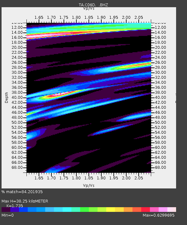
C06D Leavenworth, WQ, USA - Earthquake Result Viewer

Earthquake location: Near Coast Of Chiapas, Mexico
Earthquake latitude/longitude: 14.4/-92.9
Earthquake time(UTC): 2012/05/01 (122) 22:43:33 GMT
Earthquake Depth: 14 km
Earthquake Magnitude: 5.6 MB, 5.8 MS, 6.0 MW, 5.9 MW
Earthquake Catalog/Contributor: WHDF/NEIC
Network: TA USArray Transportable Network (new EarthScope stations)
Station: C06D Leavenworth, WQ, USA
Lat/Lon: 47.92 N/120.89 W
Elevation: 544 m
Distance: 40.7 deg
Az: 331.042 deg
Baz: 135.766 deg
Ray Param: 0.07423573
Estimated Moho Depth: 38.25 km
Estimated Crust Vp/Vs: 1.74
Assumed Crust Vp: 6.597 km/s
Estimated Crust Vs: 3.803 km/s
Estimated Crust Poisson's Ratio: 0.25
Radial Match: 84.201935 %
Radial Bump: 400
Transverse Match: 62.197815 %
Transverse Bump: 400
SOD ConfigId: 446234
Insert Time: 2012-07-28 07:19:59.513 +0000
GWidth: 2.5
Max Bumps: 400
Tol: 0.001

Signal To Noise

ChannelStoNSTALTA
TA:C06D: :BHZ:20120501T22:50:42.47501Z7.0067341.225494E-61.7490231E-7
TA:C06D: :BHN:20120501T22:50:42.47501Z1.50464455.201623E-73.4570442E-7
TA:C06D: :BHE:20120501T22:50:42.47501Z2.1019315.9149403E-72.8140502E-7
Arrivals
Ps4.6 SECOND
PpPs15 SECOND
PsPs/PpSs19 SECOND