You are here: Home > Network List > TA - USArray Transportable Network (new EarthScope stations) Stations List
> Station G35A Watkins, MN, USA > Earthquake Result Viewer
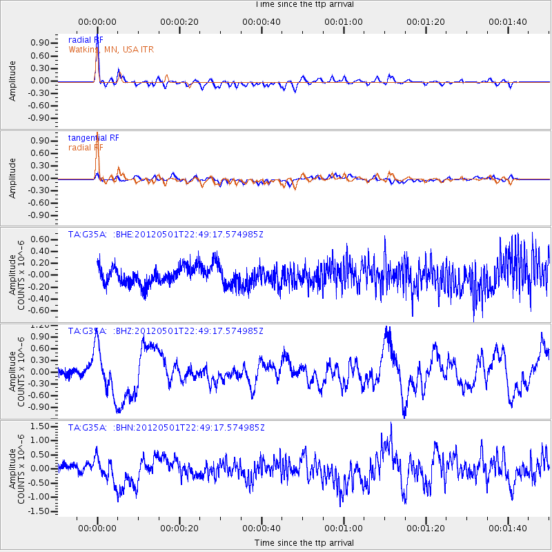
G35A Watkins, MN, USA - Earthquake Result Viewer
*The percent match for this event was below the threshold and hence no stack was calculated.
| Earthquake location: |
Near Coast Of Chiapas, Mexico |
| Earthquake latitude/longitude: |
14.4/-92.9 |
| Earthquake time(UTC): |
2012/05/01 (122) 22:43:33 GMT |
| Earthquake Depth: |
14 km |
| Earthquake Magnitude: |
5.6 MB, 5.8 MS, 6.0 MW, 5.9 MW |
| Earthquake Catalog/Contributor: |
WHDF/NEIC |
|
| Network: |
TA USArray Transportable Network (new EarthScope stations) |
| Station: |
G35A Watkins, MN, USA |
| Lat/Lon: |
45.22 N/94.49 W |
| Elevation: |
361 m |
|
| Distance: |
30.8 deg |
| Az: |
357.805 deg |
| Baz: |
176.99 deg |
| Ray Param: |
$rayparam |
*The percent match for this event was below the threshold and hence was not used in the summary stack. |
|
| Radial Match: |
77.93889 % |
| Radial Bump: |
400 |
| Transverse Match: |
57.699535 % |
| Transverse Bump: |
400 |
| SOD ConfigId: |
446234 |
| Insert Time: |
2012-07-28 07:20:50.344 +0000 |
| GWidth: |
2.5 |
| Max Bumps: |
400 |
| Tol: |
0.001 |
|
Signal To Noise
| Channel | StoN | STA | LTA |
| TA:G35A: :BHZ:20120501T22:49:17.574985Z | 7.7390943 | 6.2216026E-7 | 8.039187E-8 |
| TA:G35A: :BHN:20120501T22:49:17.574985Z | 2.412775 | 4.0475436E-7 | 1.677547E-7 |
| TA:G35A: :BHE:20120501T22:49:17.574985Z | 1.1578517 | 1.6672536E-7 | 1.4399544E-7 |
| Arrivals |
| Ps | |
| PpPs | |
| PsPs/PpSs | |


