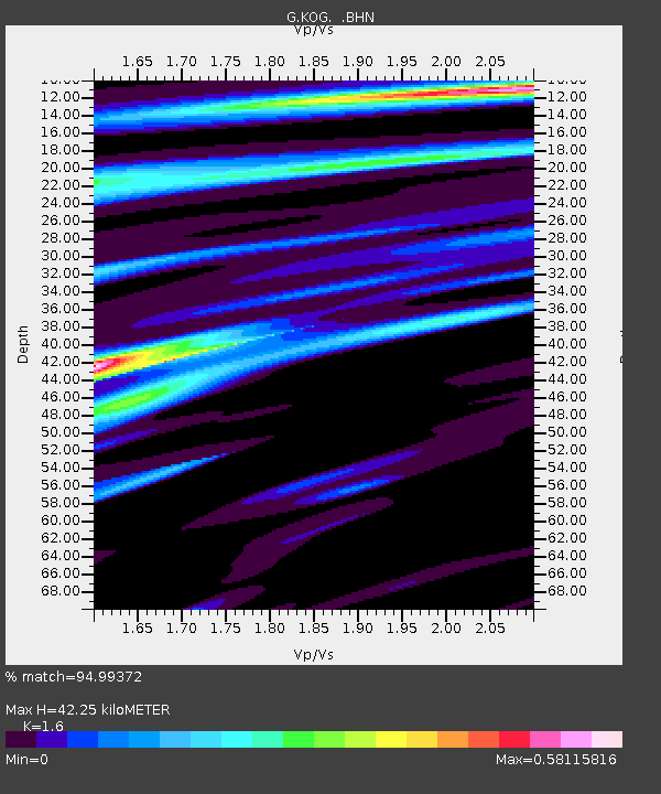
KOG Kourou, French Guyana - Earthquake Result Viewer
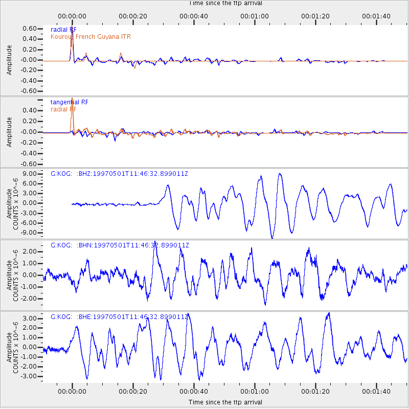
Earthquake location: Off Coast Of Jalisco, Mexico
Earthquake latitude/longitude: 19.0/-107.3
Earthquake time(UTC): 1997/05/01 (121) 11:37:36 GMT
Earthquake Depth: 33 km
Earthquake Magnitude: 6.1 MB, 6.8 MS, 7.1 UNKNOWN, 7.1 ME
Earthquake Catalog/Contributor: WHDF/NEIC
Network: G GEOSCOPE
Station: KOG Kourou, French Guyana
Lat/Lon: 5.21 N/52.73 W
Elevation: 10 m
Distance: 54.9 deg
Az: 97.108 deg
Baz: 289.474 deg
Ray Param: 0.0650809
Estimated Moho Depth: 42.25 km
Estimated Crust Vp/Vs: 1.60
Assumed Crust Vp: 6.472 km/s
Estimated Crust Vs: 4.045 km/s
Estimated Crust Poisson's Ratio: 0.18
Radial Match: 94.99372 %
Radial Bump: 400
Transverse Match: 86.29784 %
Transverse Bump: 400
SOD ConfigId: 6273
Insert Time: 2010-02-26 23:31:51.811 +0000
GWidth: 2.5
Max Bumps: 400
Tol: 0.001

Signal To Noise

ChannelStoNSTALTA
G:KOG: :BHN:19970501T11:46:32.899011Z3.5000746.78193E-71.9376533E-7
G:KOG: :BHE:19970501T11:46:32.899011Z4.03258941.5715282E-63.8970694E-7
G:KOG: :BHZ:19970501T11:46:32.899011Z22.4448384.2547817E-61.8956617E-7
Arrivals
Ps4.2 SECOND
PpPs16 SECOND
PsPs/PpSs20 SECOND