You are here: Home > Network List > TA - USArray Transportable Network (new EarthScope stations) Stations List
> Station C38A Sawbill Landing (USFS), Superior Nat. Forest, MN, > Earthquake Result Viewer
C38A Sawbill Landing (USFS), Superior Nat. Forest, MN, - Earthquake Result Viewer
| Earthquake location: |
Near Coast Of Chiapas, Mexico |
| Earthquake latitude/longitude: |
14.4/-92.9 |
| Earthquake time(UTC): |
2012/05/01 (122) 22:43:33 GMT |
| Earthquake Depth: |
14 km |
| Earthquake Magnitude: |
5.6 MB, 5.8 MS, 6.0 MW, 5.9 MW |
| Earthquake Catalog/Contributor: |
WHDF/NEIC |
|
| Network: |
TA USArray Transportable Network (new EarthScope stations) |
| Station: |
C38A Sawbill Landing (USFS), Superior Nat. Forest, MN, |
| Lat/Lon: |
47.72 N/91.27 W |
| Elevation: |
498 m |
|
| Distance: |
33.3 deg |
| Az: |
1.999 deg |
| Baz: |
182.869 deg |
| Ray Param: |
0.07827679 |
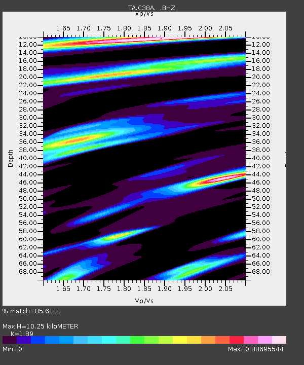
| Estimated Moho Depth: |
10.25 km |
| Estimated Crust Vp/Vs: |
1.89 |
| Assumed Crust Vp: |
6.467 km/s |
| Estimated Crust Vs: |
3.422 km/s |
| Estimated Crust Poisson's Ratio: |
0.31 |
|
| Radial Match: |
85.6111 % |
| Radial Bump: |
343 |
| Transverse Match: |
66.32854 % |
| Transverse Bump: |
400 |
| SOD ConfigId: |
446234 |
| Insert Time: |
2012-07-28 07:21:13.407 +0000 |
| GWidth: |
2.5 |
| Max Bumps: |
400 |
| Tol: |
0.001 |
|
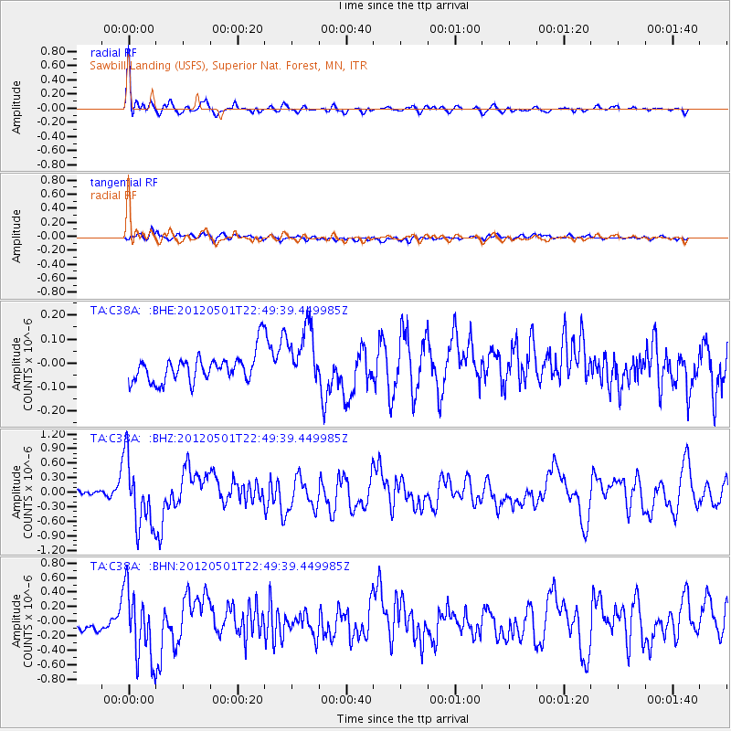
Signal To Noise
| Channel | StoN | STA | LTA |
| TA:C38A: :BHZ:20120501T22:49:39.449985Z | 8.8679905 | 6.9435856E-7 | 7.829943E-8 |
| TA:C38A: :BHN:20120501T22:49:39.449985Z | 5.4149675 | 4.7849755E-7 | 8.836573E-8 |
| TA:C38A: :BHE:20120501T22:49:39.449985Z | 2.0965323 | 1.237842E-7 | 5.9042357E-8 |
| Arrivals |
| Ps | 1.5 SECOND |
| PpPs | 4.3 SECOND |
| PsPs/PpSs | 5.8 SECOND |


