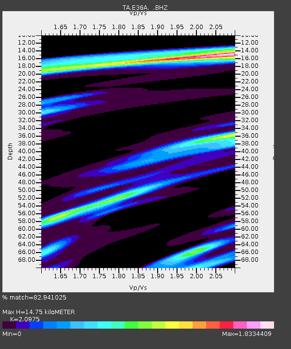
E36A McGregor, MN, USA - Earthquake Result Viewer
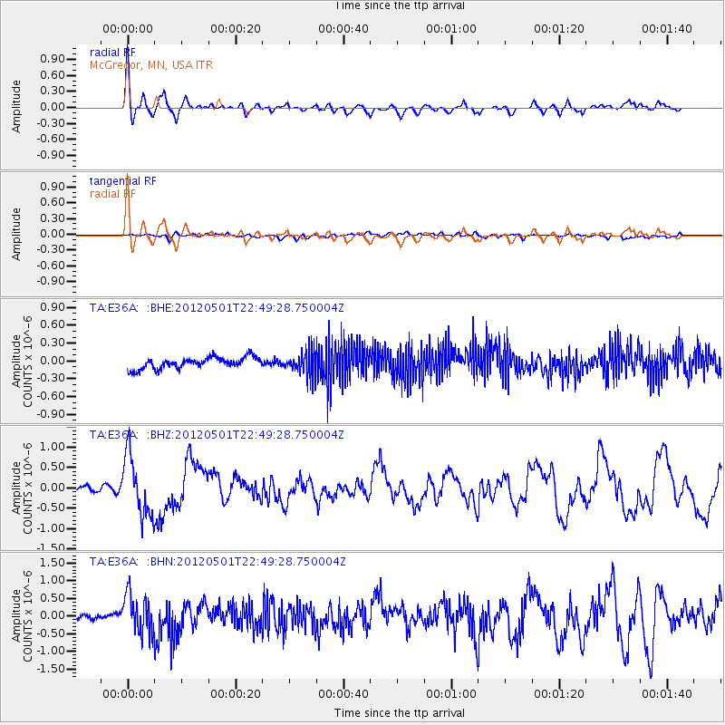
Earthquake location: Near Coast Of Chiapas, Mexico
Earthquake latitude/longitude: 14.4/-92.9
Earthquake time(UTC): 2012/05/01 (122) 22:43:33 GMT
Earthquake Depth: 14 km
Earthquake Magnitude: 5.6 MB, 5.8 MS, 6.0 MW, 5.9 MW
Earthquake Catalog/Contributor: WHDF/NEIC
Network: TA USArray Transportable Network (new EarthScope stations)
Station: E36A McGregor, MN, USA
Lat/Lon: 46.52 N/93.26 W
Elevation: 393 m
Distance: 32.0 deg
Az: 359.533 deg
Baz: 179.345 deg
Ray Param: 0.07881173
Estimated Moho Depth: 14.75 km
Estimated Crust Vp/Vs: 2.10
Assumed Crust Vp: 6.571 km/s
Estimated Crust Vs: 3.133 km/s
Estimated Crust Poisson's Ratio: 0.35
Radial Match: 82.941025 %
Radial Bump: 400
Transverse Match: 59.21672 %
Transverse Bump: 400
SOD ConfigId: 446234
Insert Time: 2012-07-28 07:21:34.444 +0000
GWidth: 2.5
Max Bumps: 400
Tol: 0.001

Signal To Noise

ChannelStoNSTALTA
TA:E36A: :BHZ:20120501T22:49:28.750004Z13.6408087.4308923E-75.4475457E-8
TA:E36A: :BHN:20120501T22:49:28.750004Z5.12730845.500681E-71.07282034E-7
TA:E36A: :BHE:20120501T22:49:28.750004Z2.09632371.9633401E-79.365635E-8
Arrivals
Ps2.6 SECOND
PpPs6.5 SECOND
PsPs/PpSs9.1 SECOND