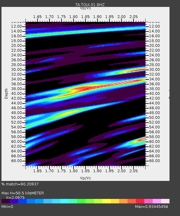
TOLK Tollok Lake Research Station, AK, USA - Earthquake Result Viewer
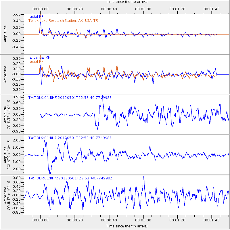
Earthquake location: Near Coast Of Chiapas, Mexico
Earthquake latitude/longitude: 14.4/-92.9
Earthquake time(UTC): 2012/05/01 (122) 22:43:33 GMT
Earthquake Depth: 14 km
Earthquake Magnitude: 5.6 MB, 5.8 MS, 6.0 MW, 5.9 MW
Earthquake Catalog/Contributor: WHDF/NEIC
Network: TA USArray Transportable Network (new EarthScope stations)
Station: TOLK Tollok Lake Research Station, AK, USA
Lat/Lon: 68.64 N/149.57 W
Elevation: 760 m
Distance: 64.9 deg
Az: 340.239 deg
Baz: 116.572 deg
Ray Param: 0.058633707
Estimated Moho Depth: 58.5 km
Estimated Crust Vp/Vs: 2.10
Assumed Crust Vp: 6.316 km/s
Estimated Crust Vs: 3.011 km/s
Estimated Crust Poisson's Ratio: 0.35
Radial Match: 90.20937 %
Radial Bump: 400
Transverse Match: 77.89175 %
Transverse Bump: 400
SOD ConfigId: 446234
Insert Time: 2012-07-28 07:22:45.075 +0000
GWidth: 2.5
Max Bumps: 400
Tol: 0.001

Signal To Noise

ChannelStoNSTALTA
TA:TOLK:01:BHZ:20120501T22:53:40.774998Z13.8742471.1096628E-67.998004E-8
TA:TOLK:01:BHN:20120501T22:53:40.774998Z3.10103632.475505E-77.982832E-8
TA:TOLK:01:BHE:20120501T22:53:40.774998Z8.5759593.8925498E-74.5389093E-8
Arrivals
Ps11 SECOND
PpPs28 SECOND
PsPs/PpSs38 SECOND