You are here: Home > Network List > G - GEOSCOPE Stations List
> Station KOG Kourou, French Guyana > Earthquake Result Viewer
KOG Kourou, French Guyana - Earthquake Result Viewer
| Earthquake location: |
Guerrero, Mexico |
| Earthquake latitude/longitude: |
18.7/-101.6 |
| Earthquake time(UTC): |
1997/05/22 (142) 07:50:53 GMT |
| Earthquake Depth: |
70 km |
| Earthquake Magnitude: |
5.9 MB, 6.0 MS, 6.6 UNKNOWN, 6.5 MW |
| Earthquake Catalog/Contributor: |
WHDF/NEIC |
|
| Network: |
G GEOSCOPE |
| Station: |
KOG Kourou, French Guyana |
| Lat/Lon: |
5.21 N/52.73 W |
| Elevation: |
10 m |
|
| Distance: |
49.5 deg |
| Az: |
99.321 deg |
| Baz: |
290.073 deg |
| Ray Param: |
0.068469234 |
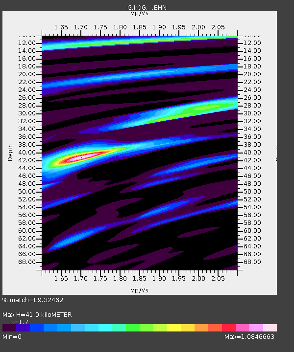
| Estimated Moho Depth: |
41.0 km |
| Estimated Crust Vp/Vs: |
1.70 |
| Assumed Crust Vp: |
6.472 km/s |
| Estimated Crust Vs: |
3.807 km/s |
| Estimated Crust Poisson's Ratio: |
0.24 |
|
| Radial Match: |
89.32462 % |
| Radial Bump: |
400 |
| Transverse Match: |
71.8656 % |
| Transverse Bump: |
400 |
| SOD ConfigId: |
6273 |
| Insert Time: |
2010-02-26 23:31:52.868 +0000 |
| GWidth: |
2.5 |
| Max Bumps: |
400 |
| Tol: |
0.001 |
|

Signal To Noise
| Channel | StoN | STA | LTA |
| G:KOG: :BHN:19970522T07:59:06.299011Z | 3.4016287 | 6.2240184E-7 | 1.8297173E-7 |
| G:KOG: :BHE:19970522T07:59:06.299011Z | 8.874785 | 1.1738273E-6 | 1.3226543E-7 |
| G:KOG: :BHZ:19970522T07:59:06.299011Z | 12.687552 | 2.9139967E-6 | 2.2967367E-7 |
| Arrivals |
| Ps | 4.7 SECOND |
| PpPs | 16 SECOND |
| PsPs/PpSs | 21 SECOND |


