E40A Wakefield, MI, USA - Earthquake Result Viewer
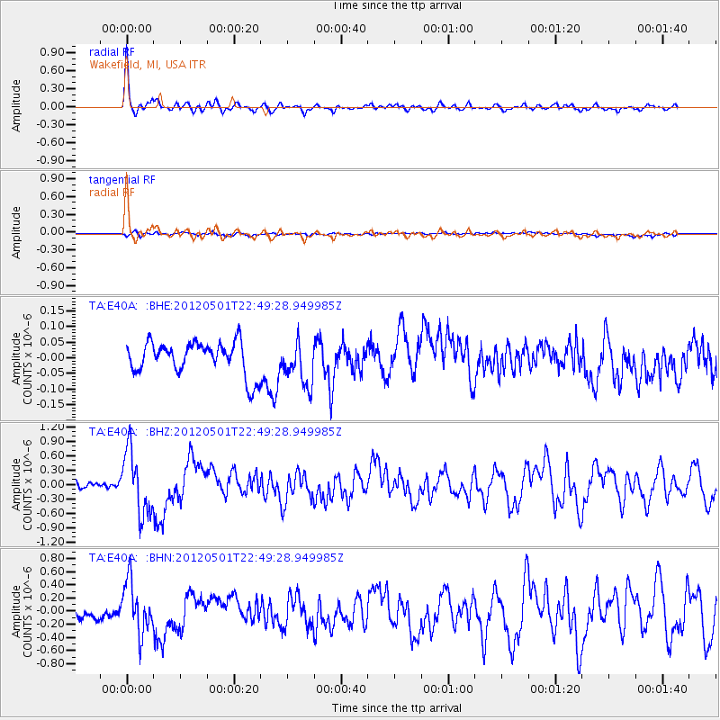
Earthquake location: Near Coast Of Chiapas, Mexico
Earthquake latitude/longitude: 14.4/-92.9
Earthquake time(UTC): 2012/05/01 (122) 22:43:33 GMT
Earthquake Depth: 14 km
Earthquake Magnitude: 5.6 MB, 5.8 MS, 6.0 MW, 5.9 MW
Earthquake Catalog/Contributor: WHDF/NEIC
Network: TA USArray Transportable Network (new EarthScope stations)
Station: E40A Wakefield, MI, USA
Lat/Lon: 46.44 N/89.90 W
Elevation: 472 m
Distance: 32.1 deg
Az: 3.906 deg
Baz: 185.478 deg
Ray Param: 0.07880128
Estimated Moho Depth: 32.0 km
Estimated Crust Vp/Vs: 1.89
Assumed Crust Vp: 6.467 km/s
Estimated Crust Vs: 3.417 km/s
Estimated Crust Poisson's Ratio: 0.31
Radial Match: 88.100784 %
Radial Bump: 370
Transverse Match: 55.993702 %
Transverse Bump: 400
SOD ConfigId: 446234
Insert Time: 2012-07-28 07:23:35.285 +0000
GWidth: 2.5
Max Bumps: 400
Tol: 0.001

Signal To Noise

ChannelStoNSTALTA
TA:E40A: :BHZ:20120501T22:49:28.949985Z8.8131136.580387E-77.466586E-8
TA:E40A: :BHN:20120501T22:49:28.949985Z4.54097033.937992E-78.6721386E-8
TA:E40A: :BHE:20120501T22:49:28.949985Z1.3757687.147344E-85.1951666E-8
Arrivals
Ps4.8 SECOND
PpPs13 SECOND
PsPs/PpSs18 SECOND