You are here: Home > Network List > TA - USArray Transportable Network (new EarthScope stations) Stations List
> Station E43A Lone Tree Farm, Eben Junction, MI, USA > Earthquake Result Viewer
E43A Lone Tree Farm, Eben Junction, MI, USA - Earthquake Result Viewer
| Earthquake location: |
Near Coast Of Chiapas, Mexico |
| Earthquake latitude/longitude: |
14.4/-92.9 |
| Earthquake time(UTC): |
2012/05/01 (122) 22:43:33 GMT |
| Earthquake Depth: |
14 km |
| Earthquake Magnitude: |
5.6 MB, 5.8 MS, 6.0 MW, 5.9 MW |
| Earthquake Catalog/Contributor: |
WHDF/NEIC |
|
| Network: |
TA USArray Transportable Network (new EarthScope stations) |
| Station: |
E43A Lone Tree Farm, Eben Junction, MI, USA |
| Lat/Lon: |
46.38 N/87.00 W |
| Elevation: |
303 m |
|
| Distance: |
32.3 deg |
| Az: |
7.659 deg |
| Baz: |
190.752 deg |
| Ray Param: |
0.07870961 |
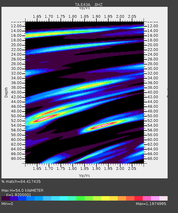
| Estimated Moho Depth: |
54.0 km |
| Estimated Crust Vp/Vs: |
1.92 |
| Assumed Crust Vp: |
6.472 km/s |
| Estimated Crust Vs: |
3.371 km/s |
| Estimated Crust Poisson's Ratio: |
0.31 |
|
| Radial Match: |
84.417435 % |
| Radial Bump: |
400 |
| Transverse Match: |
45.126778 % |
| Transverse Bump: |
400 |
| SOD ConfigId: |
446234 |
| Insert Time: |
2012-07-28 07:24:00.106 +0000 |
| GWidth: |
2.5 |
| Max Bumps: |
400 |
| Tol: |
0.001 |
|

Signal To Noise
| Channel | StoN | STA | LTA |
| TA:E43A: :BHZ:20120501T22:49:30.85001Z | 6.7066755 | 5.2908797E-7 | 7.888975E-8 |
| TA:E43A: :BHN:20120501T22:49:30.85001Z | 4.8568563 | 2.764167E-7 | 5.6912675E-8 |
| TA:E43A: :BHE:20120501T22:49:30.85001Z | 0.5937776 | 5.8218493E-8 | 9.804764E-8 |
| Arrivals |
| Ps | 8.3 SECOND |
| PpPs | 23 SECOND |
| PsPs/PpSs | 31 SECOND |


