You are here: Home > Network List > TA - USArray Transportable Network (new EarthScope stations) Stations List
> Station C40A Isle Royale National Park, MI, USA > Earthquake Result Viewer
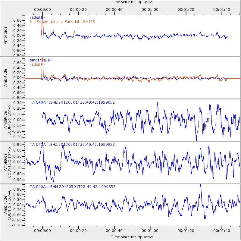
C40A Isle Royale National Park, MI, USA - Earthquake Result Viewer
*The percent match for this event was below the threshold and hence no stack was calculated.
| Earthquake location: |
Near Coast Of Chiapas, Mexico |
| Earthquake latitude/longitude: |
14.4/-92.9 |
| Earthquake time(UTC): |
2012/05/01 (122) 22:43:33 GMT |
| Earthquake Depth: |
14 km |
| Earthquake Magnitude: |
5.6 MB, 5.8 MS, 6.0 MW, 5.9 MW |
| Earthquake Catalog/Contributor: |
WHDF/NEIC |
|
| Network: |
TA USArray Transportable Network (new EarthScope stations) |
| Station: |
C40A Isle Royale National Park, MI, USA |
| Lat/Lon: |
47.92 N/89.15 W |
| Elevation: |
216 m |
|
| Distance: |
33.6 deg |
| Az: |
4.557 deg |
| Baz: |
186.572 deg |
| Ray Param: |
$rayparam |
*The percent match for this event was below the threshold and hence was not used in the summary stack. |
|
| Radial Match: |
78.52321 % |
| Radial Bump: |
400 |
| Transverse Match: |
47.970116 % |
| Transverse Bump: |
400 |
| SOD ConfigId: |
446234 |
| Insert Time: |
2012-07-28 07:24:56.610 +0000 |
| GWidth: |
2.5 |
| Max Bumps: |
400 |
| Tol: |
0.001 |
|
Signal To Noise
| Channel | StoN | STA | LTA |
| TA:C40A: :BHZ:20120501T22:49:42.199985Z | 5.0666366 | 5.515299E-7 | 1.0885523E-7 |
| TA:C40A: :BHN:20120501T22:49:42.199985Z | 3.1932385 | 3.337457E-7 | 1.0451637E-7 |
| TA:C40A: :BHE:20120501T22:49:42.199985Z | 1.3447601 | 9.005452E-8 | 6.6966976E-8 |
| Arrivals |
| Ps | |
| PpPs | |
| PsPs/PpSs | |


