You are here: Home > Network List > IW - Intermountain West Stations List
> Station PLID Pearl Lake, Idaho, USA > Earthquake Result Viewer
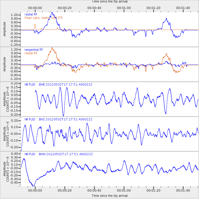
PLID Pearl Lake, Idaho, USA - Earthquake Result Viewer
*The percent match for this event was below the threshold and hence no stack was calculated.
| Earthquake location: |
Southeast Of Easter Island |
| Earthquake latitude/longitude: |
-35.9/-102.7 |
| Earthquake time(UTC): |
2012/05/02 (123) 17:06:05 GMT |
| Earthquake Depth: |
10 km |
| Earthquake Magnitude: |
5.5 MW, 4.9 MS, 4.7 MB |
| Earthquake Catalog/Contributor: |
WHDF/NEIC |
|
| Network: |
IW Intermountain West |
| Station: |
PLID Pearl Lake, Idaho, USA |
| Lat/Lon: |
45.09 N/116.00 W |
| Elevation: |
2164 m |
|
| Distance: |
81.5 deg |
| Az: |
350.535 deg |
| Baz: |
169.134 deg |
| Ray Param: |
$rayparam |
*The percent match for this event was below the threshold and hence was not used in the summary stack. |
|
| Radial Match: |
24.134317 % |
| Radial Bump: |
400 |
| Transverse Match: |
53.968502 % |
| Transverse Bump: |
400 |
| SOD ConfigId: |
446234 |
| Insert Time: |
2012-07-28 07:39:04.679 +0000 |
| GWidth: |
2.5 |
| Max Bumps: |
400 |
| Tol: |
0.001 |
|
Signal To Noise
| Channel | StoN | STA | LTA |
| IW:PLID: :BHZ:20120502T17:17:51.490022Z | 0.7880769 | 9.3514146E-8 | 1.18661205E-7 |
| IW:PLID: :BHN:20120502T17:17:51.490022Z | 1.4286646 | 4.4957704E-7 | 3.146834E-7 |
| IW:PLID: :BHE:20120502T17:17:51.490022Z | 0.39683214 | 3.2572977E-8 | 8.208251E-8 |
| Arrivals |
| Ps | |
| PpPs | |
| PsPs/PpSs | |


