You are here: Home > Network List > TA - USArray Transportable Network (new EarthScope stations) Stations List
> Station E36A McGregor, MN, USA > Earthquake Result Viewer
E36A McGregor, MN, USA - Earthquake Result Viewer
*The percent match for this event was below the threshold and hence no stack was calculated.
| Earthquake location: |
Southeast Of Easter Island |
| Earthquake latitude/longitude: |
-35.9/-102.7 |
| Earthquake time(UTC): |
2012/05/02 (123) 17:06:05 GMT |
| Earthquake Depth: |
10 km |
| Earthquake Magnitude: |
5.5 MW, 4.9 MS, 4.7 MB |
| Earthquake Catalog/Contributor: |
WHDF/NEIC |
|
| Network: |
TA USArray Transportable Network (new EarthScope stations) |
| Station: |
E36A McGregor, MN, USA |
| Lat/Lon: |
46.52 N/93.26 W |
| Elevation: |
393 m |
|
| Distance: |
82.5 deg |
| Az: |
6.583 deg |
| Baz: |
187.747 deg |
| Ray Param: |
$rayparam |
*The percent match for this event was below the threshold and hence was not used in the summary stack. |
|
| Radial Match: |
41.2423 % |
| Radial Bump: |
400 |
| Transverse Match: |
50.12566 % |
| Transverse Bump: |
400 |
| SOD ConfigId: |
446234 |
| Insert Time: |
2012-07-28 07:41:44.880 +0000 |
| GWidth: |
2.5 |
| Max Bumps: |
400 |
| Tol: |
0.001 |
|
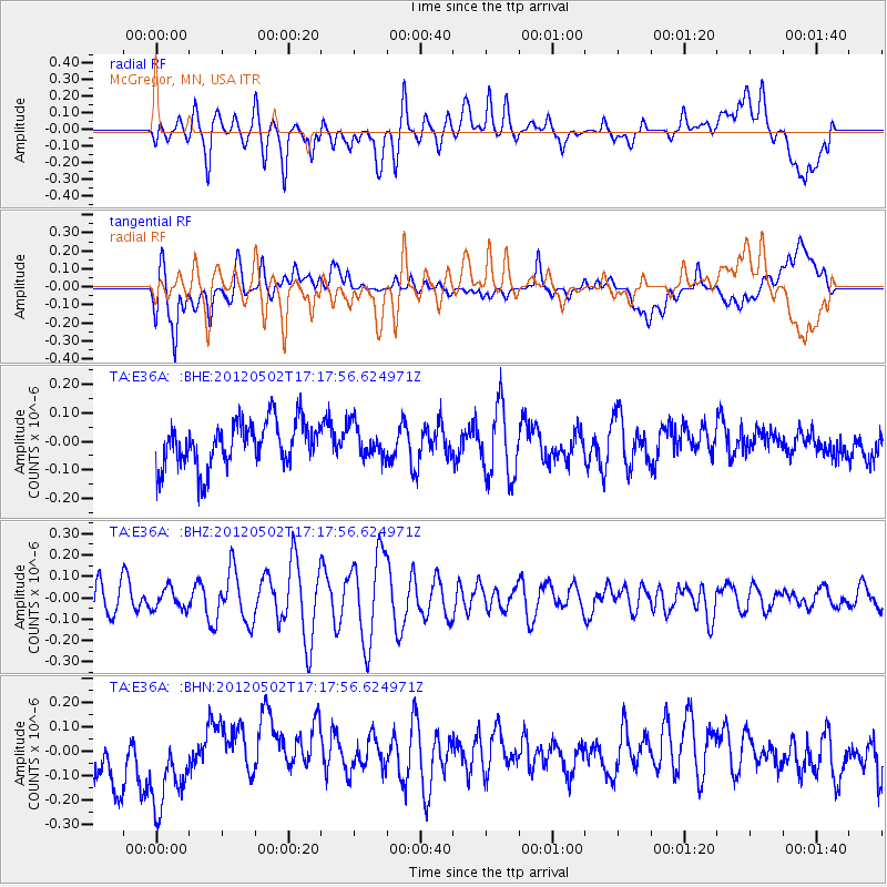
Signal To Noise
| Channel | StoN | STA | LTA |
| TA:E36A: :BHZ:20120502T17:17:56.624971Z | 0.45341396 | 4.7944212E-8 | 1.0574049E-7 |
| TA:E36A: :BHN:20120502T17:17:56.624971Z | 1.4260197 | 1.800523E-7 | 1.2626214E-7 |
| TA:E36A: :BHE:20120502T17:17:56.624971Z | 0.69276613 | 5.4121966E-8 | 7.812444E-8 |
| Arrivals |
| Ps | |
| PpPs | |
| PsPs/PpSs | |


