You are here: Home > Network List > TA - USArray Transportable Network (new EarthScope stations) Stations List
> Station C34A RKJ Ranch, Bemidji, MN, USA > Earthquake Result Viewer
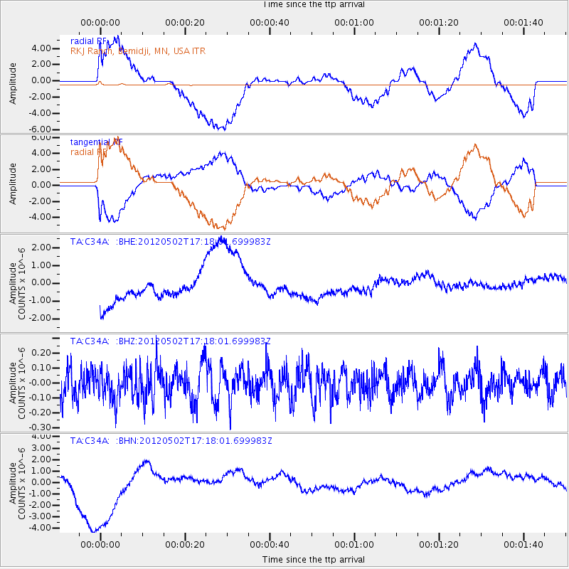
C34A RKJ Ranch, Bemidji, MN, USA - Earthquake Result Viewer
*The percent match for this event was below the threshold and hence no stack was calculated.
| Earthquake location: |
Southeast Of Easter Island |
| Earthquake latitude/longitude: |
-35.9/-102.7 |
| Earthquake time(UTC): |
2012/05/02 (123) 17:06:05 GMT |
| Earthquake Depth: |
10 km |
| Earthquake Magnitude: |
5.5 MW, 4.9 MS, 4.7 MB |
| Earthquake Catalog/Contributor: |
WHDF/NEIC |
|
| Network: |
TA USArray Transportable Network (new EarthScope stations) |
| Station: |
C34A RKJ Ranch, Bemidji, MN, USA |
| Lat/Lon: |
47.65 N/94.91 W |
| Elevation: |
441 m |
|
| Distance: |
83.5 deg |
| Az: |
5.311 deg |
| Baz: |
186.383 deg |
| Ray Param: |
$rayparam |
*The percent match for this event was below the threshold and hence was not used in the summary stack. |
|
| Radial Match: |
42.512318 % |
| Radial Bump: |
400 |
| Transverse Match: |
42.5491 % |
| Transverse Bump: |
400 |
| SOD ConfigId: |
446234 |
| Insert Time: |
2012-07-28 07:41:53.692 +0000 |
| GWidth: |
2.5 |
| Max Bumps: |
400 |
| Tol: |
0.001 |
|
Signal To Noise
| Channel | StoN | STA | LTA |
| TA:C34A: :BHZ:20120502T17:18:01.699983Z | 0.8490361 | 9.871185E-8 | 1.16263436E-7 |
| TA:C34A: :BHN:20120502T17:18:01.699983Z | 3.7871125 | 4.159201E-6 | 1.0982512E-6 |
| TA:C34A: :BHE:20120502T17:18:01.699983Z | 3.5464175 | 2.1743544E-6 | 6.1311295E-7 |
| Arrivals |
| Ps | |
| PpPs | |
| PsPs/PpSs | |


