You are here: Home > Network List > TA - USArray Transportable Network (new EarthScope stations) Stations List
> Station Y41A Eaglette Bearden, AR, USA > Earthquake Result Viewer
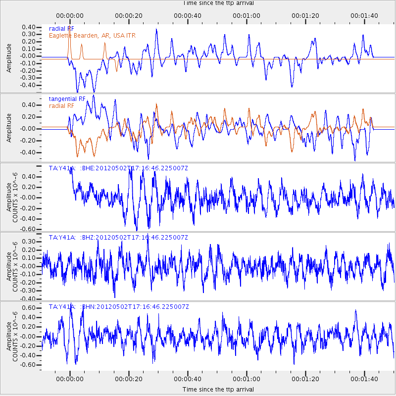
Y41A Eaglette Bearden, AR, USA - Earthquake Result Viewer
*The percent match for this event was below the threshold and hence no stack was calculated.
| Earthquake location: |
Southeast Of Easter Island |
| Earthquake latitude/longitude: |
-35.9/-102.7 |
| Earthquake time(UTC): |
2012/05/02 (123) 17:06:05 GMT |
| Earthquake Depth: |
10 km |
| Earthquake Magnitude: |
5.5 MW, 4.9 MS, 4.7 MB |
| Earthquake Catalog/Contributor: |
WHDF/NEIC |
|
| Network: |
TA USArray Transportable Network (new EarthScope stations) |
| Station: |
Y41A Eaglette Bearden, AR, USA |
| Lat/Lon: |
33.88 N/92.61 W |
| Elevation: |
99 m |
|
| Distance: |
70.0 deg |
| Az: |
8.944 deg |
| Baz: |
188.729 deg |
| Ray Param: |
$rayparam |
*The percent match for this event was below the threshold and hence was not used in the summary stack. |
|
| Radial Match: |
35.03588 % |
| Radial Bump: |
400 |
| Transverse Match: |
51.014595 % |
| Transverse Bump: |
400 |
| SOD ConfigId: |
446234 |
| Insert Time: |
2012-07-28 07:43:08.245 +0000 |
| GWidth: |
2.5 |
| Max Bumps: |
400 |
| Tol: |
0.001 |
|
Signal To Noise
| Channel | StoN | STA | LTA |
| TA:Y41A: :BHZ:20120502T17:16:46.225007Z | 0.64330053 | 8.160284E-8 | 1.2685027E-7 |
| TA:Y41A: :BHN:20120502T17:16:46.225007Z | 1.9991324 | 3.9702516E-7 | 1.9859874E-7 |
| TA:Y41A: :BHE:20120502T17:16:46.225007Z | 0.89368546 | 2.1161145E-7 | 2.3678516E-7 |
| Arrivals |
| Ps | |
| PpPs | |
| PsPs/PpSs | |


