You are here: Home > Network List > G - GEOSCOPE Stations List
> Station TAM Tamanrasset, Algeria > Earthquake Result Viewer
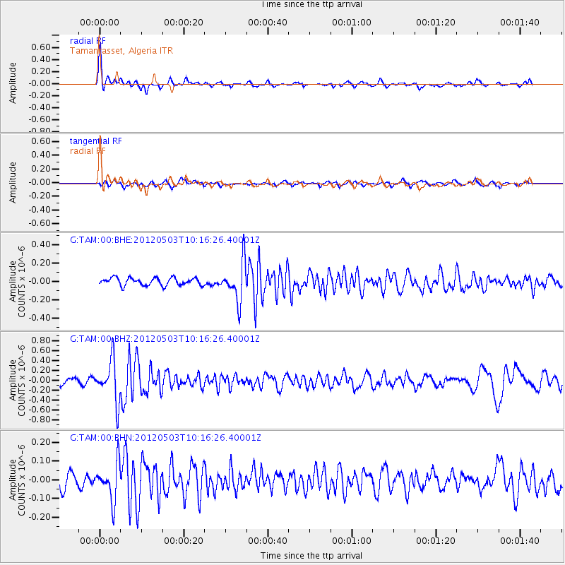
TAM Tamanrasset, Algeria - Earthquake Result Viewer
*The percent match for this event was below the threshold and hence no stack was calculated.
| Earthquake location: |
Iran-Iraq Border Region |
| Earthquake latitude/longitude: |
32.7/47.7 |
| Earthquake time(UTC): |
2012/05/03 (124) 10:09:35 GMT |
| Earthquake Depth: |
10 km |
| Earthquake Magnitude: |
5.6 MB, 5.2 MW, 5.4 MW |
| Earthquake Catalog/Contributor: |
WHDF/NEIC |
|
| Network: |
G GEOSCOPE |
| Station: |
TAM Tamanrasset, Algeria |
| Lat/Lon: |
22.79 N/5.53 E |
| Elevation: |
1377 m |
|
| Distance: |
38.4 deg |
| Az: |
265.988 deg |
| Baz: |
65.634 deg |
| Ray Param: |
$rayparam |
*The percent match for this event was below the threshold and hence was not used in the summary stack. |
|
| Radial Match: |
79.49877 % |
| Radial Bump: |
400 |
| Transverse Match: |
61.21715 % |
| Transverse Bump: |
400 |
| SOD ConfigId: |
446234 |
| Insert Time: |
2012-07-28 07:54:14.172 +0000 |
| GWidth: |
2.5 |
| Max Bumps: |
400 |
| Tol: |
0.001 |
|
Signal To Noise
| Channel | StoN | STA | LTA |
| G:TAM:00:BHZ:20120503T10:16:26.40001Z | 7.891842 | 4.2275366E-7 | 5.356844E-8 |
| G:TAM:00:BHN:20120503T10:16:26.40001Z | 1.7764046 | 1.0296971E-7 | 5.7965234E-8 |
| G:TAM:00:BHE:20120503T10:16:26.40001Z | 5.2870173 | 2.1674977E-7 | 4.0996607E-8 |
| Arrivals |
| Ps | |
| PpPs | |
| PsPs/PpSs | |


