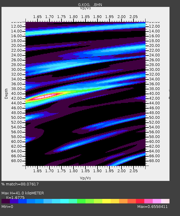
KOG Kourou, French Guyana - Earthquake Result Viewer

Earthquake location: Near Coast Of Oaxaca, Mexico
Earthquake latitude/longitude: 15.9/-96.3
Earthquake time(UTC): 1998/02/03 (034) 03:02:00 GMT
Earthquake Depth: 33 km
Earthquake Magnitude: 6.0 MB, 6.2 MS, 6.3 UNKNOWN, 6.4 MD
Earthquake Catalog/Contributor: WHDF/NEIC
Network: G GEOSCOPE
Station: KOG Kourou, French Guyana
Lat/Lon: 5.21 N/52.73 W
Elevation: 10 m
Distance: 44.0 deg
Az: 99.065 deg
Baz: 287.414 deg
Ray Param: 0.07210204
Estimated Moho Depth: 41.0 km
Estimated Crust Vp/Vs: 1.68
Assumed Crust Vp: 6.472 km/s
Estimated Crust Vs: 3.858 km/s
Estimated Crust Poisson's Ratio: 0.22
Radial Match: 88.07617 %
Radial Bump: 327
Transverse Match: 68.00578 %
Transverse Bump: 400
SOD ConfigId: 6273
Insert Time: 2010-02-26 23:32:18.283 +0000
GWidth: 2.5
Max Bumps: 400
Tol: 0.001

Signal To Noise

ChannelStoNSTALTA
G:KOG: :BHN:19980203T03:09:34.200Z1.18304041.8196324E-71.5380985E-7
G:KOG: :BHE:19980203T03:09:34.200Z2.40685874.0243629E-71.6720394E-7
G:KOG: :BHZ:19980203T03:09:34.200Z4.5252879.697095E-72.1428684E-7
Arrivals
Ps4.6 SECOND
PpPs16 SECOND
PsPs/PpSs20 SECOND