You are here: Home > Network List > TA - USArray Transportable Network (new EarthScope stations) Stations List
> Station D37A Cotton, MN, USA > Earthquake Result Viewer
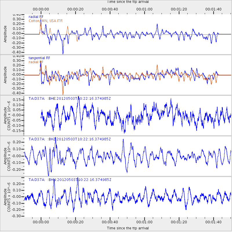
D37A Cotton, MN, USA - Earthquake Result Viewer
*The percent match for this event was below the threshold and hence no stack was calculated.
| Earthquake location: |
Iran-Iraq Border Region |
| Earthquake latitude/longitude: |
32.7/47.7 |
| Earthquake time(UTC): |
2012/05/03 (124) 10:09:35 GMT |
| Earthquake Depth: |
10 km |
| Earthquake Magnitude: |
5.6 MB, 5.2 MW, 5.4 MW |
| Earthquake Catalog/Contributor: |
WHDF/NEIC |
|
| Network: |
TA USArray Transportable Network (new EarthScope stations) |
| Station: |
D37A Cotton, MN, USA |
| Lat/Lon: |
47.16 N/92.43 W |
| Elevation: |
413 m |
|
| Distance: |
92.8 deg |
| Az: |
334.038 deg |
| Baz: |
32.724 deg |
| Ray Param: |
$rayparam |
*The percent match for this event was below the threshold and hence was not used in the summary stack. |
|
| Radial Match: |
51.88564 % |
| Radial Bump: |
400 |
| Transverse Match: |
51.601566 % |
| Transverse Bump: |
400 |
| SOD ConfigId: |
446234 |
| Insert Time: |
2012-07-28 07:57:31.292 +0000 |
| GWidth: |
2.5 |
| Max Bumps: |
400 |
| Tol: |
0.001 |
|
Signal To Noise
| Channel | StoN | STA | LTA |
| TA:D37A: :BHZ:20120503T10:22:16.374985Z | 1.6288319 | 1.1675169E-7 | 7.167817E-8 |
| TA:D37A: :BHN:20120503T10:22:16.374985Z | 1.9163069 | 8.616939E-8 | 4.4966384E-8 |
| TA:D37A: :BHE:20120503T10:22:16.374985Z | 0.96811974 | 6.635682E-8 | 6.854195E-8 |
| Arrivals |
| Ps | |
| PpPs | |
| PsPs/PpSs | |


