You are here: Home > Network List > TA - USArray Transportable Network (new EarthScope stations) Stations List
> Station B34A Aery, Baudette, MN, USA > Earthquake Result Viewer
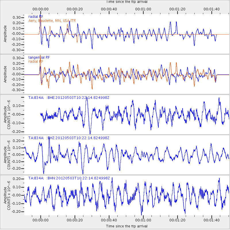
B34A Aery, Baudette, MN, USA - Earthquake Result Viewer
*The percent match for this event was below the threshold and hence no stack was calculated.
| Earthquake location: |
Iran-Iraq Border Region |
| Earthquake latitude/longitude: |
32.7/47.7 |
| Earthquake time(UTC): |
2012/05/03 (124) 10:09:35 GMT |
| Earthquake Depth: |
10 km |
| Earthquake Magnitude: |
5.6 MB, 5.2 MW, 5.4 MW |
| Earthquake Catalog/Contributor: |
WHDF/NEIC |
|
| Network: |
TA USArray Transportable Network (new EarthScope stations) |
| Station: |
B34A Aery, Baudette, MN, USA |
| Lat/Lon: |
48.49 N/94.65 W |
| Elevation: |
354 m |
|
| Distance: |
92.4 deg |
| Az: |
336.014 deg |
| Baz: |
30.992 deg |
| Ray Param: |
$rayparam |
*The percent match for this event was below the threshold and hence was not used in the summary stack. |
|
| Radial Match: |
64.7307 % |
| Radial Bump: |
400 |
| Transverse Match: |
62.00041 % |
| Transverse Bump: |
400 |
| SOD ConfigId: |
446234 |
| Insert Time: |
2012-07-28 07:57:36.125 +0000 |
| GWidth: |
2.5 |
| Max Bumps: |
400 |
| Tol: |
0.001 |
|
Signal To Noise
| Channel | StoN | STA | LTA |
| TA:B34A: :BHZ:20120503T10:22:14.824998Z | 2.2441928 | 1.4712168E-7 | 6.555661E-8 |
| TA:B34A: :BHN:20120503T10:22:14.824998Z | 1.0805254 | 5.8583673E-8 | 5.4217765E-8 |
| TA:B34A: :BHE:20120503T10:22:14.824998Z | 1.9853338 | 7.875645E-8 | 3.966912E-8 |
| Arrivals |
| Ps | |
| PpPs | |
| PsPs/PpSs | |


