You are here: Home > Network List > TA - USArray Transportable Network (new EarthScope stations) Stations List
> Station E36A McGregor, MN, USA > Earthquake Result Viewer
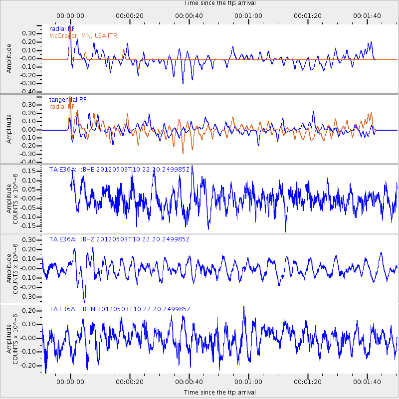
E36A McGregor, MN, USA - Earthquake Result Viewer
*The percent match for this event was below the threshold and hence no stack was calculated.
| Earthquake location: |
Iran-Iraq Border Region |
| Earthquake latitude/longitude: |
32.7/47.7 |
| Earthquake time(UTC): |
2012/05/03 (124) 10:09:35 GMT |
| Earthquake Depth: |
10 km |
| Earthquake Magnitude: |
5.6 MB, 5.2 MW, 5.4 MW |
| Earthquake Catalog/Contributor: |
WHDF/NEIC |
|
| Network: |
TA USArray Transportable Network (new EarthScope stations) |
| Station: |
E36A McGregor, MN, USA |
| Lat/Lon: |
46.52 N/93.26 W |
| Elevation: |
393 m |
|
| Distance: |
93.6 deg |
| Az: |
334.176 deg |
| Baz: |
32.113 deg |
| Ray Param: |
$rayparam |
*The percent match for this event was below the threshold and hence was not used in the summary stack. |
|
| Radial Match: |
60.291683 % |
| Radial Bump: |
400 |
| Transverse Match: |
58.689533 % |
| Transverse Bump: |
400 |
| SOD ConfigId: |
446234 |
| Insert Time: |
2012-07-28 07:58:02.594 +0000 |
| GWidth: |
2.5 |
| Max Bumps: |
400 |
| Tol: |
0.001 |
|
Signal To Noise
| Channel | StoN | STA | LTA |
| TA:E36A: :BHZ:20120503T10:22:20.249985Z | 1.2853541 | 1.4927991E-7 | 1.16139134E-7 |
| TA:E36A: :BHN:20120503T10:22:20.249985Z | 1.12687 | 8.786532E-8 | 7.797289E-8 |
| TA:E36A: :BHE:20120503T10:22:20.249985Z | 1.1573195 | 6.2741094E-8 | 5.421242E-8 |
| Arrivals |
| Ps | |
| PpPs | |
| PsPs/PpSs | |


