You are here: Home > Network List > IM - International Miscellaneous Stations Stations List
> Station IL31 ILAR Array, Eilson, AK, USA > Earthquake Result Viewer
IL31 ILAR Array, Eilson, AK, USA - Earthquake Result Viewer
| Earthquake location: |
Tonga Islands |
| Earthquake latitude/longitude: |
-21.5/-174.2 |
| Earthquake time(UTC): |
2012/05/05 (126) 20:23:31 GMT |
| Earthquake Depth: |
8.5 km |
| Earthquake Magnitude: |
5.6 MS, 5.7 MW, 5.6 MW |
| Earthquake Catalog/Contributor: |
WHDF/NEIC |
|
| Network: |
IM International Miscellaneous Stations |
| Station: |
IL31 ILAR Array, Eilson, AK, USA |
| Lat/Lon: |
64.77 N/146.89 W |
| Elevation: |
419 m |
|
| Distance: |
88.5 deg |
| Az: |
11.356 deg |
| Baz: |
205.335 deg |
| Ray Param: |
0.042523075 |
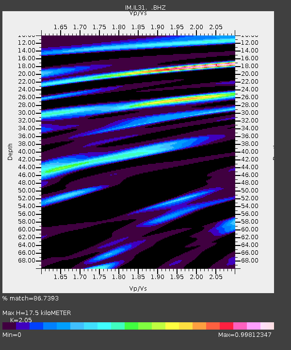
| Estimated Moho Depth: |
17.5 km |
| Estimated Crust Vp/Vs: |
2.05 |
| Assumed Crust Vp: |
6.566 km/s |
| Estimated Crust Vs: |
3.203 km/s |
| Estimated Crust Poisson's Ratio: |
0.34 |
|
| Radial Match: |
86.7393 % |
| Radial Bump: |
400 |
| Transverse Match: |
80.94715 % |
| Transverse Bump: |
400 |
| SOD ConfigId: |
446234 |
| Insert Time: |
2012-07-28 08:11:13.970 +0000 |
| GWidth: |
2.5 |
| Max Bumps: |
400 |
| Tol: |
0.001 |
|

Signal To Noise
| Channel | StoN | STA | LTA |
| IM:IL31: :BHZ:20120505T20:35:52.550015Z | 7.2211585 | 2.1846702E-8 | 3.0253735E-9 |
| IM:IL31: :BHN:20120505T20:35:52.550015Z | 2.2624676 | 5.778942E-9 | 2.554265E-9 |
| IM:IL31: :BHE:20120505T20:35:52.550015Z | 3.5787659 | 8.666996E-9 | 2.4217834E-9 |
| Arrivals |
| Ps | 2.9 SECOND |
| PpPs | 8.0 SECOND |
| PsPs/PpSs | 11 SECOND |


