You are here: Home > Network List > G - GEOSCOPE Stations List
> Station KOG Kourou, French Guyana > Earthquake Result Viewer
KOG Kourou, French Guyana - Earthquake Result Viewer
| Earthquake location: |
Ascension Island Region |
| Earthquake latitude/longitude: |
-11.6/-13.9 |
| Earthquake time(UTC): |
1998/06/18 (169) 04:17:54 GMT |
| Earthquake Depth: |
10 km |
| Earthquake Magnitude: |
6.1 MS, 5.4 MB, 6.2 UNKNOWN |
| Earthquake Catalog/Contributor: |
WHDF/NEIC |
|
| Network: |
G GEOSCOPE |
| Station: |
KOG Kourou, French Guyana |
| Lat/Lon: |
5.21 N/52.73 W |
| Elevation: |
10 m |
|
| Distance: |
42.1 deg |
| Az: |
291.256 deg |
| Baz: |
113.508 deg |
| Ray Param: |
0.073383555 |
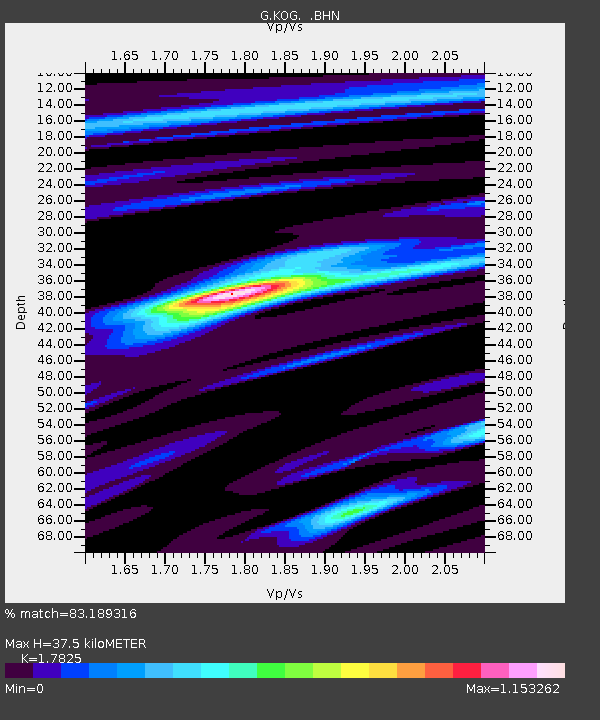
| Estimated Moho Depth: |
37.5 km |
| Estimated Crust Vp/Vs: |
1.78 |
| Assumed Crust Vp: |
6.472 km/s |
| Estimated Crust Vs: |
3.631 km/s |
| Estimated Crust Poisson's Ratio: |
0.27 |
|
| Radial Match: |
83.189316 % |
| Radial Bump: |
311 |
| Transverse Match: |
46.09669 % |
| Transverse Bump: |
400 |
| SOD ConfigId: |
4480 |
| Insert Time: |
2010-02-26 23:32:32.768 +0000 |
| GWidth: |
2.5 |
| Max Bumps: |
400 |
| Tol: |
0.001 |
|

Signal To Noise
| Channel | StoN | STA | LTA |
| G:KOG: :BHN:19980618T04:25:15.966986Z | 4.954832 | 6.6648215E-7 | 1.3451155E-7 |
| G:KOG: :BHE:19980618T04:25:15.966986Z | 2.676006 | 2.446772E-7 | 9.1433726E-8 |
| G:KOG: :BHZ:19980618T04:25:15.966986Z | 2.137366 | 3.4642898E-7 | 1.620822E-7 |
| Arrivals |
| Ps | 4.9 SECOND |
| PpPs | 15 SECOND |
| PsPs/PpSs | 20 SECOND |


