You are here: Home > Network List > G - GEOSCOPE Stations List
> Station KOG Kourou, French Guyana > Earthquake Result Viewer
KOG Kourou, French Guyana - Earthquake Result Viewer

| Earthquake location: |
Azores Islands, Portugal |
| Earthquake latitude/longitude: |
38.7/-28.6 |
| Earthquake time(UTC): |
1998/07/09 (190) 05:19:07 GMT |
| Earthquake Depth: |
10 km |
| Earthquake Magnitude: |
5.7 MB, 6.0 MS, 6.6 UNKNOWN, 6.2 MW |
| Earthquake Catalog/Contributor: |
WHDF/NEIC |
|
| Network: |
G GEOSCOPE |
| Station: |
KOG Kourou, French Guyana |
| Lat/Lon: |
5.21 N/52.73 W |
| Elevation: |
10 m |
|
| Distance: |
39.8 deg |
| Az: |
219.42 deg |
| Baz: |
29.95 deg |
| Ray Param: |
0.07475202 |
| Estimated Moho Depth: |
27.5 km |
| Estimated Crust Vp/Vs: |
2.10 |
| Assumed Crust Vp: |
6.472 km/s |
| Estimated Crust Vs: |
3.089 km/s |
| Estimated Crust Poisson's Ratio: |
0.35 |
|
| Radial Match: |
94.96103 % |
| Radial Bump: |
209 |
| Transverse Match: |
78.45061 % |
| Transverse Bump: |
379 |
| SOD ConfigId: |
4480 |
| Insert Time: |
2010-02-26 23:32:33.936 +0000 |
| GWidth: |
2.5 |
| Max Bumps: |
400 |
| Tol: |
0.001 |
|
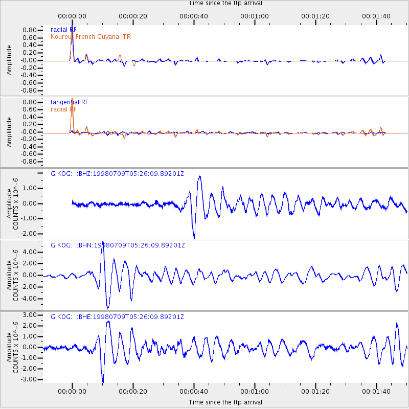
Signal To Noise
| Channel | StoN | STA | LTA |
| G:KOG: :BHN:19980709T05:26:09.89201Z | 3.4289296 | 2.6865885E-7 | 7.835065E-8 |
| G:KOG: :BHE:19980709T05:26:09.89201Z | 1.7112132 | 1.5137284E-7 | 8.8459366E-8 |
| G:KOG: :BHZ:19980709T05:26:09.89201Z | 1.3441548 | 1.0550177E-7 | 7.84893E-8 |
| Arrivals |
| Ps | 4.9 SECOND |
| PpPs | 12 SECOND |
| PsPs/PpSs | 17 SECOND |


