You are here: Home > Network List > TA - USArray Transportable Network (new EarthScope stations) Stations List
> Station V39A Pettigrew, AR, USA > Earthquake Result Viewer
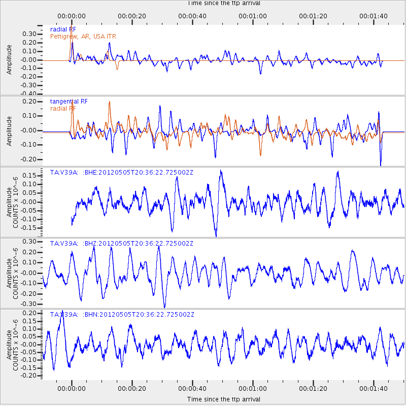
V39A Pettigrew, AR, USA - Earthquake Result Viewer
*The percent match for this event was below the threshold and hence no stack was calculated.
| Earthquake location: |
Tonga Islands |
| Earthquake latitude/longitude: |
-21.5/-174.2 |
| Earthquake time(UTC): |
2012/05/05 (126) 20:23:31 GMT |
| Earthquake Depth: |
8.5 km |
| Earthquake Magnitude: |
5.6 MS, 5.7 MW, 5.6 MW |
| Earthquake Catalog/Contributor: |
WHDF/NEIC |
|
| Network: |
TA USArray Transportable Network (new EarthScope stations) |
| Station: |
V39A Pettigrew, AR, USA |
| Lat/Lon: |
35.84 N/93.64 W |
| Elevation: |
744 m |
|
| Distance: |
95.1 deg |
| Az: |
53.583 deg |
| Baz: |
247.287 deg |
| Ray Param: |
$rayparam |
*The percent match for this event was below the threshold and hence was not used in the summary stack. |
|
| Radial Match: |
44.833515 % |
| Radial Bump: |
400 |
| Transverse Match: |
47.513477 % |
| Transverse Bump: |
398 |
| SOD ConfigId: |
446234 |
| Insert Time: |
2012-07-28 08:33:16.215 +0000 |
| GWidth: |
2.5 |
| Max Bumps: |
400 |
| Tol: |
0.001 |
|
Signal To Noise
| Channel | StoN | STA | LTA |
| TA:V39A: :BHZ:20120505T20:36:22.725002Z | 2.3257008 | 1.3265281E-7 | 5.703778E-8 |
| TA:V39A: :BHN:20120505T20:36:22.725002Z | 0.9456281 | 5.6621875E-8 | 5.987753E-8 |
| TA:V39A: :BHE:20120505T20:36:22.725002Z | 1.7808727 | 7.6867536E-8 | 4.316285E-8 |
| Arrivals |
| Ps | |
| PpPs | |
| PsPs/PpSs | |


