You are here: Home > Network List > G - GEOSCOPE Stations List
> Station KOG Kourou, French Guyana > Earthquake Result Viewer
KOG Kourou, French Guyana - Earthquake Result Viewer
| Earthquake location: |
Near Coast Of Peru |
| Earthquake latitude/longitude: |
-15.0/-75.7 |
| Earthquake time(UTC): |
1996/11/12 (317) 16:59:44 GMT |
| Earthquake Depth: |
33 km |
| Earthquake Magnitude: |
6.5 MB, 7.3 MS, 7.7 UNKNOWN, 7.7 MW |
| Earthquake Catalog/Contributor: |
WHDF/NEIC |
|
| Network: |
G GEOSCOPE |
| Station: |
KOG Kourou, French Guyana |
| Lat/Lon: |
5.21 N/52.73 W |
| Elevation: |
10 m |
|
| Distance: |
30.3 deg |
| Az: |
50.248 deg |
| Baz: |
228.247 deg |
| Ray Param: |
0.079329744 |
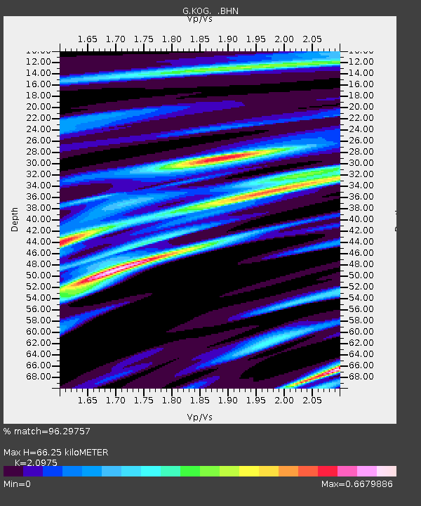
| Estimated Moho Depth: |
66.25 km |
| Estimated Crust Vp/Vs: |
2.10 |
| Assumed Crust Vp: |
6.472 km/s |
| Estimated Crust Vs: |
3.086 km/s |
| Estimated Crust Poisson's Ratio: |
0.35 |
|
| Radial Match: |
96.29757 % |
| Radial Bump: |
267 |
| Transverse Match: |
86.2454 % |
| Transverse Bump: |
400 |
| SOD ConfigId: |
4480 |
| Insert Time: |
2010-02-26 23:32:39.042 +0000 |
| GWidth: |
2.5 |
| Max Bumps: |
400 |
| Tol: |
0.001 |
|

Signal To Noise
| Channel | StoN | STA | LTA |
| G:KOG: :BHN:19961112T17:05:22.238007Z | 33.861042 | 1.254165E-5 | 3.703858E-7 |
| G:KOG: :BHE:19961112T17:05:22.238007Z | 11.958306 | 5.1189018E-6 | 4.2806244E-7 |
| G:KOG: :BHZ:19961112T17:05:22.238007Z | 14.719871 | 5.903694E-6 | 4.0106968E-7 |
| Arrivals |
| Ps | 12 SECOND |
| PpPs | 30 SECOND |
| PsPs/PpSs | 42 SECOND |


