You are here: Home > Network List > G - GEOSCOPE Stations List
> Station KOG Kourou, French Guyana > Earthquake Result Viewer
KOG Kourou, French Guyana - Earthquake Result Viewer
| Earthquake location: |
Michoacan, Mexico |
| Earthquake latitude/longitude: |
18.2/-102.8 |
| Earthquake time(UTC): |
1997/01/11 (011) 20:28:26 GMT |
| Earthquake Depth: |
33 km |
| Earthquake Magnitude: |
6.5 MB, 6.9 MS, 7.1 UNKNOWN, 7.0 ME |
| Earthquake Catalog/Contributor: |
WHDF/NEIC |
|
| Network: |
G GEOSCOPE |
| Station: |
KOG Kourou, French Guyana |
| Lat/Lon: |
5.21 N/52.73 W |
| Elevation: |
10 m |
|
| Distance: |
50.5 deg |
| Az: |
98.433 deg |
| Baz: |
289.256 deg |
| Ray Param: |
0.06795556 |
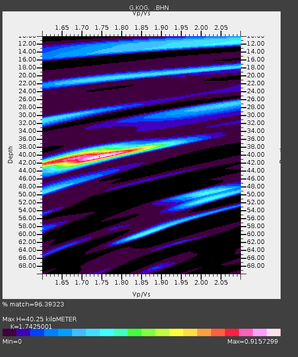
| Estimated Moho Depth: |
40.25 km |
| Estimated Crust Vp/Vs: |
1.74 |
| Assumed Crust Vp: |
6.472 km/s |
| Estimated Crust Vs: |
3.714 km/s |
| Estimated Crust Poisson's Ratio: |
0.25 |
|
| Radial Match: |
96.39323 % |
| Radial Bump: |
400 |
| Transverse Match: |
82.99216 % |
| Transverse Bump: |
400 |
| SOD ConfigId: |
4480 |
| Insert Time: |
2010-02-26 23:32:43.124 +0000 |
| GWidth: |
2.5 |
| Max Bumps: |
400 |
| Tol: |
0.001 |
|
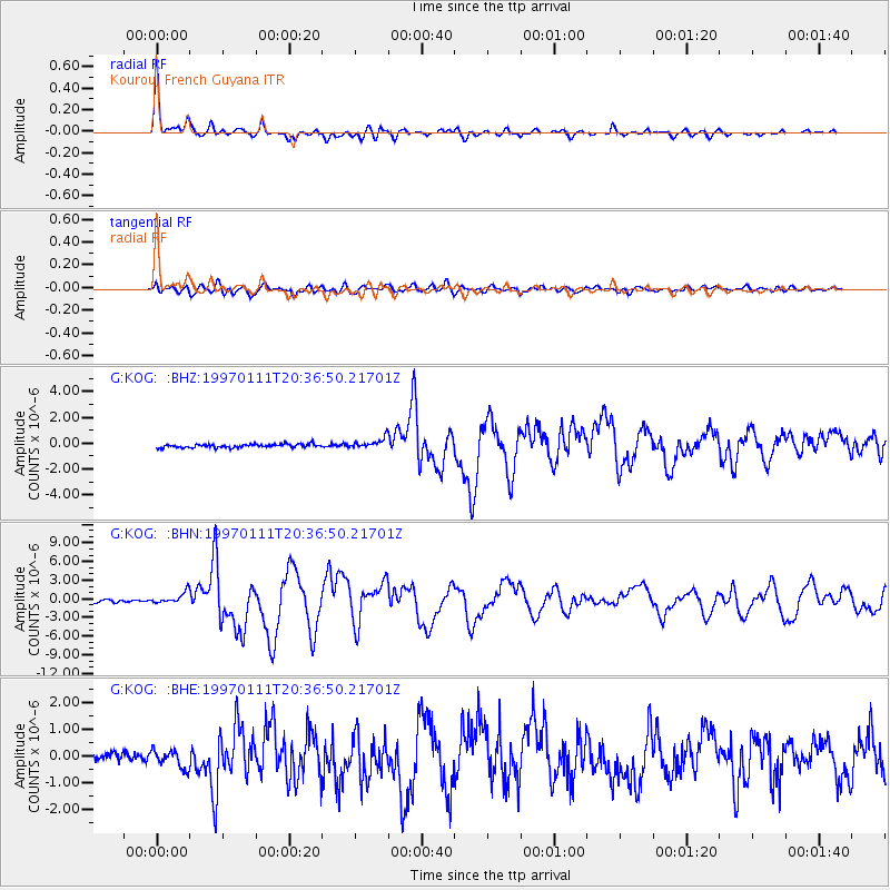
Signal To Noise
| Channel | StoN | STA | LTA |
| G:KOG: :BHN:19970111T20:36:50.21701Z | 4.7514415 | 9.2597816E-7 | 1.9488363E-7 |
| G:KOG: :BHE:19970111T20:36:50.21701Z | 1.9245213 | 3.2858128E-7 | 1.7073403E-7 |
| G:KOG: :BHZ:19970111T20:36:50.21701Z | 2.9822843 | 3.9337775E-7 | 1.3190484E-7 |
| Arrivals |
| Ps | 4.9 SECOND |
| PpPs | 16 SECOND |
| PsPs/PpSs | 21 SECOND |


