You are here: Home > Network List > TA - USArray Transportable Network (new EarthScope stations) Stations List
> Station R11A Troy Canyon, Currant, NV, USA > Earthquake Result Viewer
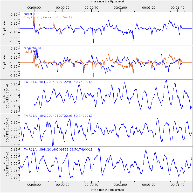
R11A Troy Canyon, Currant, NV, USA - Earthquake Result Viewer
*The percent match for this event was below the threshold and hence no stack was calculated.
| Earthquake location: |
Solomon Islands |
| Earthquake latitude/longitude: |
-7.0/154.9 |
| Earthquake time(UTC): |
2014/05/09 (129) 21:51:08 GMT |
| Earthquake Depth: |
41 km |
| Earthquake Magnitude: |
5.2 MW |
| Earthquake Catalog/Contributor: |
ISC/ISC |
|
| Network: |
TA USArray Transportable Network (new EarthScope stations) |
| Station: |
R11A Troy Canyon, Currant, NV, USA |
| Lat/Lon: |
38.35 N/115.59 W |
| Elevation: |
1756 m |
|
| Distance: |
93.9 deg |
| Az: |
52.003 deg |
| Baz: |
264.228 deg |
| Ray Param: |
$rayparam |
*The percent match for this event was below the threshold and hence was not used in the summary stack. |
|
| Radial Match: |
49.96766 % |
| Radial Bump: |
400 |
| Transverse Match: |
49.97784 % |
| Transverse Bump: |
400 |
| SOD ConfigId: |
3390531 |
| Insert Time: |
2019-04-11 19:16:27.770 +0000 |
| GWidth: |
2.5 |
| Max Bumps: |
400 |
| Tol: |
0.001 |
|
Signal To Noise
| Channel | StoN | STA | LTA |
| TA:R11A: :BHZ:20140509T22:03:50.749001Z | 1.6275291 | 7.6582246E-8 | 4.70543E-8 |
| TA:R11A: :BHN:20140509T22:03:50.749001Z | 1.1357113 | 6.5759714E-8 | 5.7901786E-8 |
| TA:R11A: :BHE:20140509T22:03:50.749001Z | 1.4695805 | 6.427149E-8 | 4.373458E-8 |
| Arrivals |
| Ps | |
| PpPs | |
| PsPs/PpSs | |


