You are here: Home > Network List > TA - USArray Transportable Network (new EarthScope stations) Stations List
> Station I33A Coleman, SD, USA > Earthquake Result Viewer
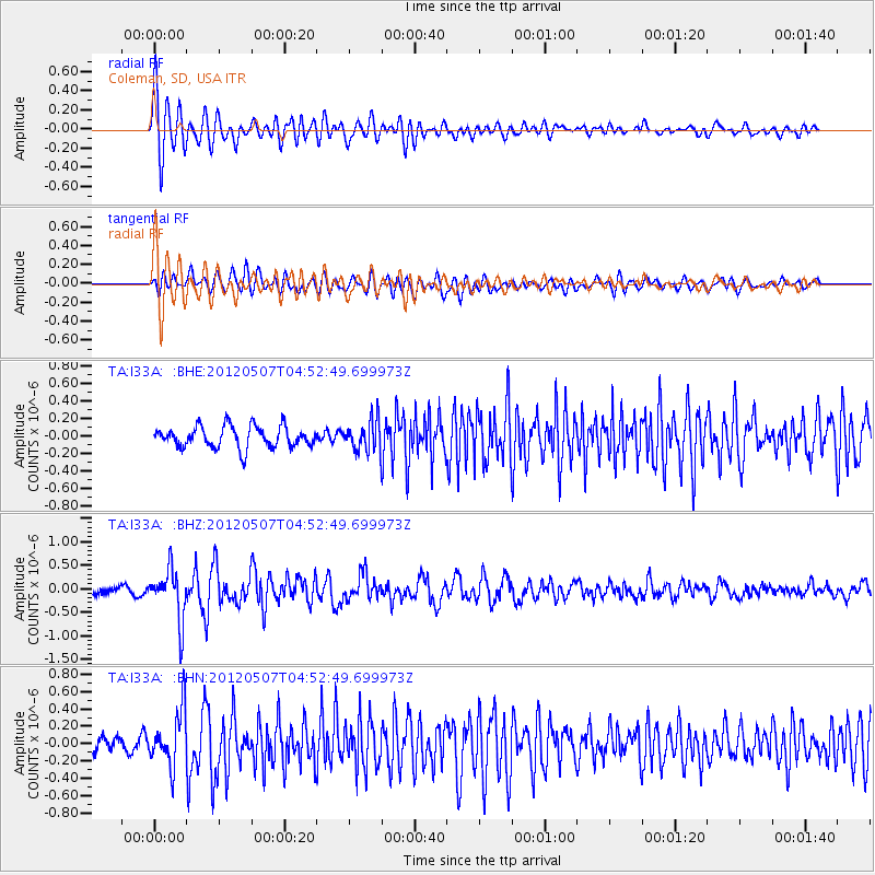
I33A Coleman, SD, USA - Earthquake Result Viewer

| Earthquake location: |
Eastern Caucasus |
| Earthquake latitude/longitude: |
41.5/46.8 |
| Earthquake time(UTC): |
2012/05/07 (128) 04:40:27 GMT |
| Earthquake Depth: |
11 km |
| Earthquake Magnitude: |
5.7 MB, 5.7 MS, 5.6 MW, 5.6 MW |
| Earthquake Catalog/Contributor: |
WHDF/NEIC |
|
| Network: |
TA USArray Transportable Network (new EarthScope stations) |
| Station: |
I33A Coleman, SD, USA |
| Lat/Lon: |
44.05 N/96.80 W |
| Elevation: |
509 m |
|
| Distance: |
88.7 deg |
| Az: |
334.651 deg |
| Baz: |
26.465 deg |
| Ray Param: |
0.042369597 |
| Estimated Moho Depth: |
39.25 km |
| Estimated Crust Vp/Vs: |
1.65 |
| Assumed Crust Vp: |
6.552 km/s |
| Estimated Crust Vs: |
3.959 km/s |
| Estimated Crust Poisson's Ratio: |
0.21 |
|
| Radial Match: |
81.79 % |
| Radial Bump: |
400 |
| Transverse Match: |
70.96419 % |
| Transverse Bump: |
400 |
| SOD ConfigId: |
446234 |
| Insert Time: |
2012-08-05 04:18:02.137 +0000 |
| GWidth: |
2.5 |
| Max Bumps: |
400 |
| Tol: |
0.001 |
|
Signal To Noise
| Channel | StoN | STA | LTA |
| TA:I33A: :BHZ:20120507T04:52:49.699973Z | 6.5217757 | 5.416475E-7 | 8.305215E-8 |
| TA:I33A: :BHN:20120507T04:52:49.699973Z | 2.7285066 | 3.210568E-7 | 1.1766759E-7 |
| TA:I33A: :BHE:20120507T04:52:49.699973Z | 1.4768953 | 1.7796422E-7 | 1.2049888E-7 |
| Arrivals |
| Ps | 4.0 SECOND |
| PpPs | 16 SECOND |
| PsPs/PpSs | 20 SECOND |


