You are here: Home > Network List > TA - USArray Transportable Network (new EarthScope stations) Stations List
> Station H31A Wolsey, SD, USA > Earthquake Result Viewer
H31A Wolsey, SD, USA - Earthquake Result Viewer
| Earthquake location: |
Eastern Caucasus |
| Earthquake latitude/longitude: |
41.5/46.8 |
| Earthquake time(UTC): |
2012/05/07 (128) 04:40:27 GMT |
| Earthquake Depth: |
11 km |
| Earthquake Magnitude: |
5.7 MB, 5.7 MS, 5.6 MW, 5.6 MW |
| Earthquake Catalog/Contributor: |
WHDF/NEIC |
|
| Network: |
TA USArray Transportable Network (new EarthScope stations) |
| Station: |
H31A Wolsey, SD, USA |
| Lat/Lon: |
44.48 N/98.48 W |
| Elevation: |
415 m |
|
| Distance: |
88.9 deg |
| Az: |
335.924 deg |
| Baz: |
25.325 deg |
| Ray Param: |
0.042266347 |
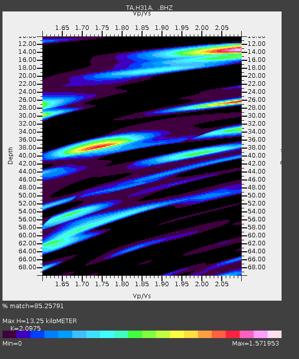
| Estimated Moho Depth: |
13.25 km |
| Estimated Crust Vp/Vs: |
2.10 |
| Assumed Crust Vp: |
6.53 km/s |
| Estimated Crust Vs: |
3.113 km/s |
| Estimated Crust Poisson's Ratio: |
0.35 |
|
| Radial Match: |
85.25791 % |
| Radial Bump: |
400 |
| Transverse Match: |
66.873344 % |
| Transverse Bump: |
400 |
| SOD ConfigId: |
446234 |
| Insert Time: |
2012-08-05 04:18:27.043 +0000 |
| GWidth: |
2.5 |
| Max Bumps: |
400 |
| Tol: |
0.001 |
|
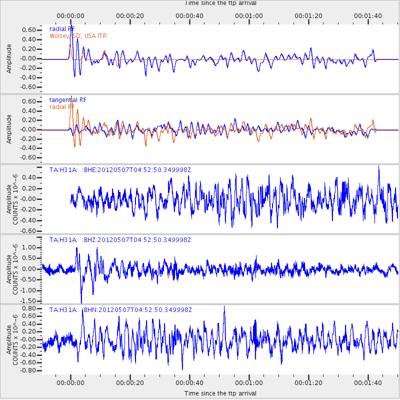
Signal To Noise
| Channel | StoN | STA | LTA |
| TA:H31A: :BHZ:20120507T04:52:50.349998Z | 4.570665 | 5.0420766E-7 | 1.10313856E-7 |
| TA:H31A: :BHN:20120507T04:52:50.349998Z | 2.13208 | 2.6516796E-7 | 1.2437054E-7 |
| TA:H31A: :BHE:20120507T04:52:50.349998Z | 1.5985667 | 1.8676495E-7 | 1.1683276E-7 |
| Arrivals |
| Ps | 2.3 SECOND |
| PpPs | 6.2 SECOND |
| PsPs/PpSs | 8.4 SECOND |


