You are here: Home > Network List > UW - Pacific Northwest Regional Seismic Network Stations List
> Station PASS Maple Falls, WA, USA > Earthquake Result Viewer
PASS Maple Falls, WA, USA - Earthquake Result Viewer
| Earthquake location: |
Solomon Islands |
| Earthquake latitude/longitude: |
-7.0/154.9 |
| Earthquake time(UTC): |
2014/05/09 (129) 21:51:08 GMT |
| Earthquake Depth: |
41 km |
| Earthquake Magnitude: |
5.2 MW |
| Earthquake Catalog/Contributor: |
ISC/ISC |
|
| Network: |
UW Pacific Northwest Regional Seismic Network |
| Station: |
PASS Maple Falls, WA, USA |
| Lat/Lon: |
49.00 N/122.09 W |
| Elevation: |
174 m |
|
| Distance: |
90.6 deg |
| Az: |
40.822 deg |
| Baz: |
260.174 deg |
| Ray Param: |
0.041653745 |
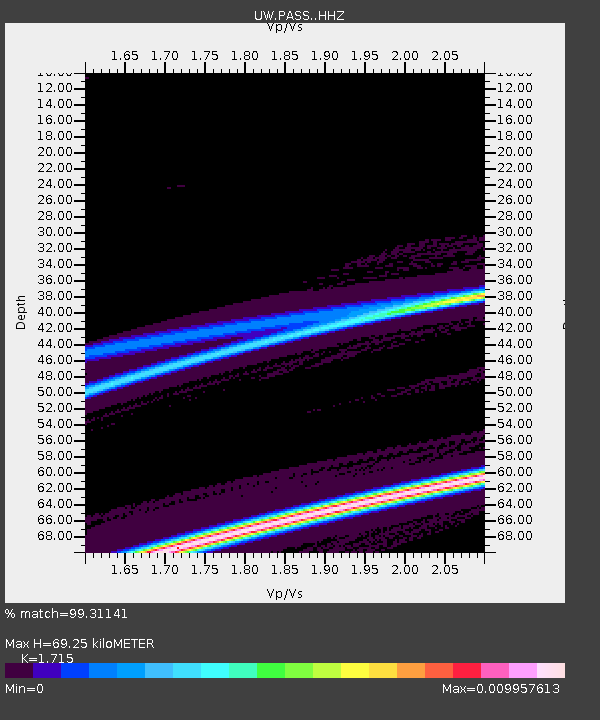
| Estimated Moho Depth: |
69.25 km |
| Estimated Crust Vp/Vs: |
1.72 |
| Assumed Crust Vp: |
6.566 km/s |
| Estimated Crust Vs: |
3.829 km/s |
| Estimated Crust Poisson's Ratio: |
0.24 |
|
| Radial Match: |
99.31141 % |
| Radial Bump: |
27 |
| Transverse Match: |
99.95942 % |
| Transverse Bump: |
6 |
| SOD ConfigId: |
3390531 |
| Insert Time: |
2019-04-11 19:17:05.286 +0000 |
| GWidth: |
2.5 |
| Max Bumps: |
400 |
| Tol: |
0.001 |
|
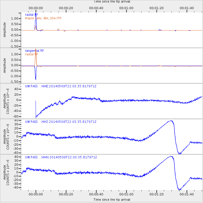
Signal To Noise
| Channel | StoN | STA | LTA |
| UW:PASS: :HHZ:20140509T22:03:35.817971Z | 1.4071759 | 2.4068207E-5 | 1.710391E-5 |
| UW:PASS: :HHN:20140509T22:03:35.817971Z | 1.394509 | 2.5669824E-5 | 1.8407787E-5 |
| UW:PASS: :HHE:20140509T22:03:35.817971Z | 1.3943595 | 2.592197E-5 | 1.8590596E-5 |
| Arrivals |
| Ps | 7.7 SECOND |
| PpPs | 28 SECOND |
| PsPs/PpSs | 36 SECOND |


