You are here: Home > Network List > TA - USArray Transportable Network (new EarthScope stations) Stations List
> Station E34A Wadena, MN, USA > Earthquake Result Viewer
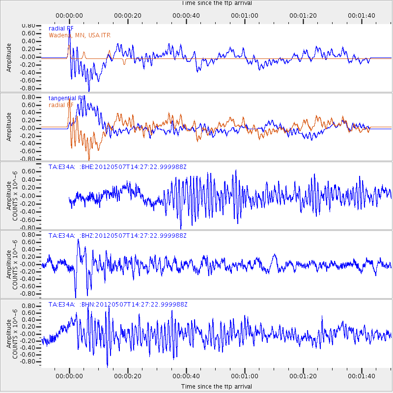
E34A Wadena, MN, USA - Earthquake Result Viewer
*The percent match for this event was below the threshold and hence no stack was calculated.
| Earthquake location: |
Eastern Caucasus |
| Earthquake latitude/longitude: |
41.6/46.7 |
| Earthquake time(UTC): |
2012/05/07 (128) 14:15:14 GMT |
| Earthquake Depth: |
12 km |
| Earthquake Magnitude: |
5.6 MB, 5.0 MS, 5.3 MW, 5.4 MW |
| Earthquake Catalog/Contributor: |
WHDF/NEIC |
|
| Network: |
TA USArray Transportable Network (new EarthScope stations) |
| Station: |
E34A Wadena, MN, USA |
| Lat/Lon: |
46.51 N/95.17 W |
| Elevation: |
430 m |
|
| Distance: |
86.0 deg |
| Az: |
334.704 deg |
| Baz: |
27.67 deg |
| Ray Param: |
$rayparam |
*The percent match for this event was below the threshold and hence was not used in the summary stack. |
|
| Radial Match: |
77.68975 % |
| Radial Bump: |
400 |
| Transverse Match: |
60.64687 % |
| Transverse Bump: |
400 |
| SOD ConfigId: |
446234 |
| Insert Time: |
2012-08-05 04:55:00.558 +0000 |
| GWidth: |
2.5 |
| Max Bumps: |
400 |
| Tol: |
0.001 |
|
Signal To Noise
| Channel | StoN | STA | LTA |
| TA:E34A: :BHZ:20120507T14:27:22.999988Z | 4.0131087 | 3.3924593E-7 | 8.453445E-8 |
| TA:E34A: :BHN:20120507T14:27:22.999988Z | 3.1203 | 3.7969943E-7 | 1.2168682E-7 |
| TA:E34A: :BHE:20120507T14:27:22.999988Z | 1.5643364 | 2.027556E-7 | 1.2961125E-7 |
| Arrivals |
| Ps | |
| PpPs | |
| PsPs/PpSs | |


