You are here: Home > Network List > TA - USArray Transportable Network (new EarthScope stations) Stations List
> Station G35A Watkins, MN, USA > Earthquake Result Viewer
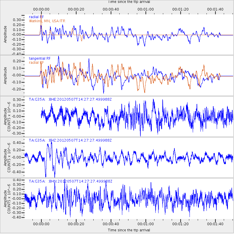
G35A Watkins, MN, USA - Earthquake Result Viewer
*The percent match for this event was below the threshold and hence no stack was calculated.
| Earthquake location: |
Eastern Caucasus |
| Earthquake latitude/longitude: |
41.6/46.7 |
| Earthquake time(UTC): |
2012/05/07 (128) 14:15:14 GMT |
| Earthquake Depth: |
12 km |
| Earthquake Magnitude: |
5.6 MB, 5.0 MS, 5.3 MW, 5.4 MW |
| Earthquake Catalog/Contributor: |
WHDF/NEIC |
|
| Network: |
TA USArray Transportable Network (new EarthScope stations) |
| Station: |
G35A Watkins, MN, USA |
| Lat/Lon: |
45.22 N/94.49 W |
| Elevation: |
361 m |
|
| Distance: |
86.9 deg |
| Az: |
333.675 deg |
| Baz: |
28.095 deg |
| Ray Param: |
$rayparam |
*The percent match for this event was below the threshold and hence was not used in the summary stack. |
|
| Radial Match: |
50.069847 % |
| Radial Bump: |
400 |
| Transverse Match: |
58.979404 % |
| Transverse Bump: |
400 |
| SOD ConfigId: |
446234 |
| Insert Time: |
2012-08-05 04:55:43.709 +0000 |
| GWidth: |
2.5 |
| Max Bumps: |
400 |
| Tol: |
0.001 |
|
Signal To Noise
| Channel | StoN | STA | LTA |
| TA:G35A: :BHZ:20120507T14:27:27.499988Z | 2.9343944 | 2.2629933E-7 | 7.711961E-8 |
| TA:G35A: :BHN:20120507T14:27:27.499988Z | 1.1824524 | 9.307761E-8 | 7.871573E-8 |
| TA:G35A: :BHE:20120507T14:27:27.499988Z | 1.3666353 | 1.1050295E-7 | 8.0857674E-8 |
| Arrivals |
| Ps | |
| PpPs | |
| PsPs/PpSs | |


