You are here: Home > Network List > TA - USArray Transportable Network (new EarthScope stations) Stations List
> Station A33A Warroad, MN, USA > Earthquake Result Viewer
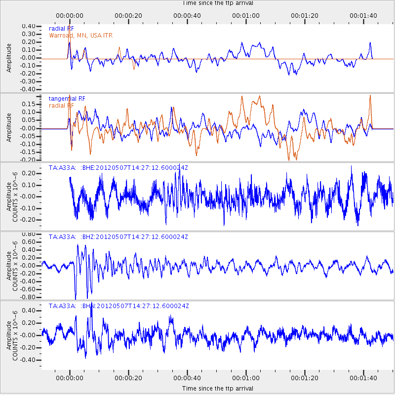
A33A Warroad, MN, USA - Earthquake Result Viewer
*The percent match for this event was below the threshold and hence no stack was calculated.
| Earthquake location: |
Eastern Caucasus |
| Earthquake latitude/longitude: |
41.6/46.7 |
| Earthquake time(UTC): |
2012/05/07 (128) 14:15:14 GMT |
| Earthquake Depth: |
12 km |
| Earthquake Magnitude: |
5.6 MB, 5.0 MS, 5.3 MW, 5.4 MW |
| Earthquake Catalog/Contributor: |
WHDF/NEIC |
|
| Network: |
TA USArray Transportable Network (new EarthScope stations) |
| Station: |
A33A Warroad, MN, USA |
| Lat/Lon: |
48.94 N/95.39 W |
| Elevation: |
329 m |
|
| Distance: |
83.9 deg |
| Az: |
335.966 deg |
| Baz: |
27.618 deg |
| Ray Param: |
$rayparam |
*The percent match for this event was below the threshold and hence was not used in the summary stack. |
|
| Radial Match: |
46.958023 % |
| Radial Bump: |
400 |
| Transverse Match: |
37.781628 % |
| Transverse Bump: |
400 |
| SOD ConfigId: |
446234 |
| Insert Time: |
2012-08-05 04:56:16.775 +0000 |
| GWidth: |
2.5 |
| Max Bumps: |
400 |
| Tol: |
0.001 |
|
Signal To Noise
| Channel | StoN | STA | LTA |
| TA:A33A: :BHZ:20120507T14:27:12.600024Z | 2.5442526 | 2.923209E-7 | 1.148946E-7 |
| TA:A33A: :BHN:20120507T14:27:12.600024Z | 1.9596632 | 1.4777214E-7 | 7.540691E-8 |
| TA:A33A: :BHE:20120507T14:27:12.600024Z | 1.0176423 | 8.2911235E-8 | 8.147385E-8 |
| Arrivals |
| Ps | |
| PpPs | |
| PsPs/PpSs | |


