You are here: Home > Network List > G - GEOSCOPE Stations List
> Station MBO M'Bour, Senegal > Earthquake Result Viewer
MBO M'Bour, Senegal - Earthquake Result Viewer
| Earthquake location: |
Afghanistan-Tajikistan Bord Reg. |
| Earthquake latitude/longitude: |
36.5/71.0 |
| Earthquake time(UTC): |
2004/04/05 (096) 21:24:04 GMT |
| Earthquake Depth: |
187 km |
| Earthquake Magnitude: |
6.4 MB, 6.6 MW, 6.5 MW |
| Earthquake Catalog/Contributor: |
WHDF/NEIC |
|
| Network: |
G GEOSCOPE |
| Station: |
MBO M'Bour, Senegal |
| Lat/Lon: |
14.39 N/16.95 W |
| Elevation: |
3.0 m |
|
| Distance: |
80.0 deg |
| Az: |
280.459 deg |
| Baz: |
54.843 deg |
| Ray Param: |
0.04812248 |
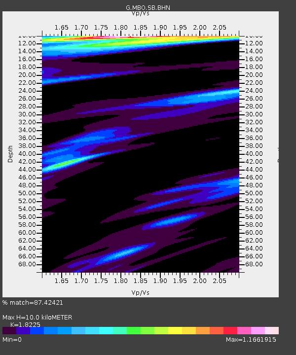
| Estimated Moho Depth: |
10.0 km |
| Estimated Crust Vp/Vs: |
1.82 |
| Assumed Crust Vp: |
5.55 km/s |
| Estimated Crust Vs: |
3.045 km/s |
| Estimated Crust Poisson's Ratio: |
0.28 |
|
| Radial Match: |
87.42421 % |
| Radial Bump: |
298 |
| Transverse Match: |
73.91554 % |
| Transverse Bump: |
400 |
| SOD ConfigId: |
2459 |
| Insert Time: |
2010-02-26 23:33:12.413 +0000 |
| GWidth: |
2.5 |
| Max Bumps: |
400 |
| Tol: |
0.001 |
|
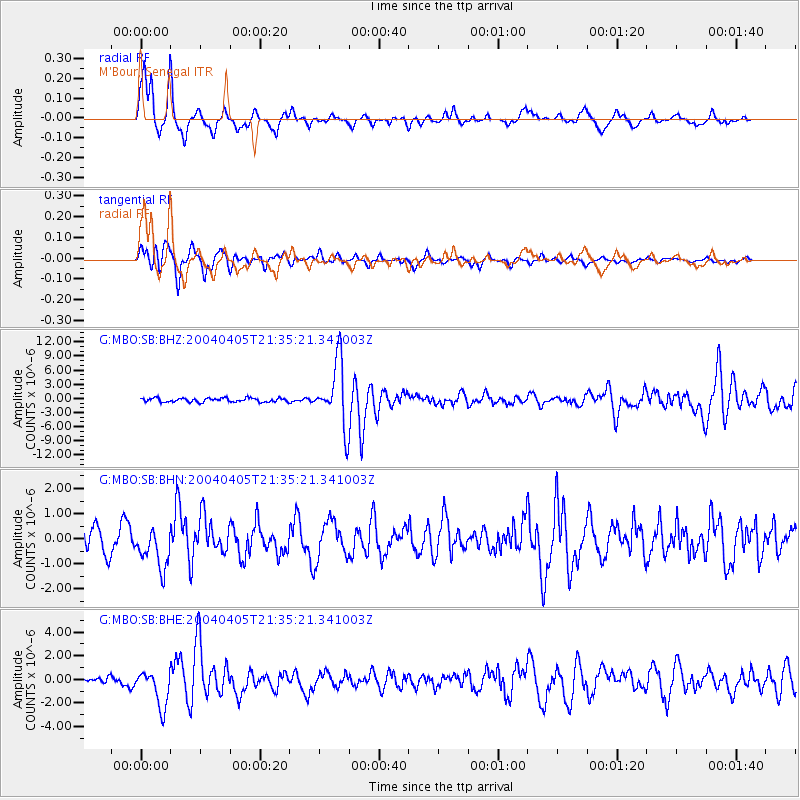
Signal To Noise
| Channel | StoN | STA | LTA |
| G:MBO:SB:BHN:20040405T21:35:21.341003Z | 1.8019488 | 8.025253E-7 | 4.453652E-7 |
| G:MBO:SB:BHE:20040405T21:35:21.341003Z | 4.8534365 | 1.5503408E-6 | 3.1943156E-7 |
| G:MBO:SB:BHZ:20040405T21:35:21.341003Z | 16.631784 | 6.828626E-6 | 4.1057686E-7 |
| Arrivals |
| Ps | 1.5 SECOND |
| PpPs | 5.0 SECOND |
| PsPs/PpSs | 6.5 SECOND |


