You are here: Home > Network List > TA - USArray Transportable Network (new EarthScope stations) Stations List
> Station F39A Loretta, WI, USA > Earthquake Result Viewer
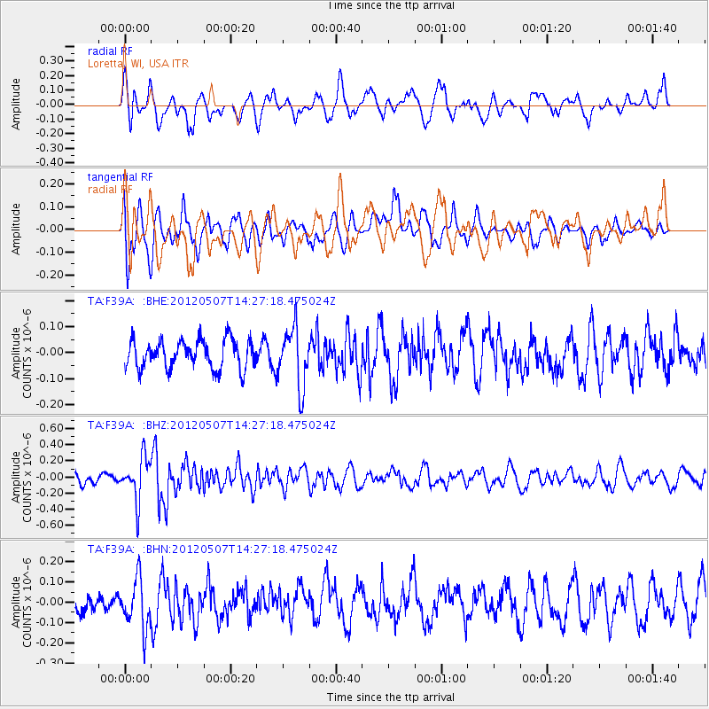
F39A Loretta, WI, USA - Earthquake Result Viewer
*The percent match for this event was below the threshold and hence no stack was calculated.
| Earthquake location: |
Eastern Caucasus |
| Earthquake latitude/longitude: |
41.6/46.7 |
| Earthquake time(UTC): |
2012/05/07 (128) 14:15:14 GMT |
| Earthquake Depth: |
12 km |
| Earthquake Magnitude: |
5.6 MB, 5.0 MS, 5.3 MW, 5.4 MW |
| Earthquake Catalog/Contributor: |
WHDF/NEIC |
|
| Network: |
TA USArray Transportable Network (new EarthScope stations) |
| Station: |
F39A Loretta, WI, USA |
| Lat/Lon: |
45.92 N/90.92 W |
| Elevation: |
440 m |
|
| Distance: |
85.1 deg |
| Az: |
331.826 deg |
| Baz: |
30.505 deg |
| Ray Param: |
$rayparam |
*The percent match for this event was below the threshold and hence was not used in the summary stack. |
|
| Radial Match: |
74.80843 % |
| Radial Bump: |
400 |
| Transverse Match: |
68.30715 % |
| Transverse Bump: |
400 |
| SOD ConfigId: |
446234 |
| Insert Time: |
2012-08-05 05:02:38.652 +0000 |
| GWidth: |
2.5 |
| Max Bumps: |
400 |
| Tol: |
0.001 |
|
Signal To Noise
| Channel | StoN | STA | LTA |
| TA:F39A: :BHZ:20120507T14:27:18.475024Z | 2.9765801 | 2.6984972E-7 | 9.0657636E-8 |
| TA:F39A: :BHN:20120507T14:27:18.475024Z | 1.346973 | 1.227392E-7 | 9.1122246E-8 |
| TA:F39A: :BHE:20120507T14:27:18.475024Z | 2.0760999 | 1.1367773E-7 | 5.4755425E-8 |
| Arrivals |
| Ps | |
| PpPs | |
| PsPs/PpSs | |


